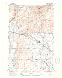
1949 Map of Toston
USGS Topo · Published 1970About this map
The Missouri River carves a deep path through this mid-century landscape, serving as the central artery for a complex system of industrial and agricultural infrastructure. Near the settlement of Toston, the river's power is managed by the Toston Dam, which feeds an extensive irrigation network including the Toston Canal and Lombard Canal. This infrastructure was vital for the area's development, as evidenced by the engineering noted at Toston Tunnel and the nearby Siphon.
Find a feature on this map
42 named features on this map. Tap any name to fly to it.
Don’t see what you’re looking for? This feature index may not catch every label — zoom into the map to look around manually.
Map Details
Editions of this 1949 Toston Map
This is the sole edition of this map. No revisions or reprints were ever made.
Other maps of this area

1886 · Fort Logan
USGS Topo · 1:250,000

1888 · Three Forks
USGS Topo · 1:250,000

1894 · Three Forks
USGS Topo · 1:250,000

1895 · Three Forks
USGS Topo · 1:250,000

1947 · Bozeman
USGS Topo · 1:250,000

1948 · Bozeman
USGS Topo · 1:250,000

1948 · White Sulphur Springs
USGS Topo · 1:250,000

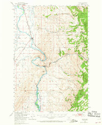
1949 · Radersburg
USGS Topo · 1:62,500
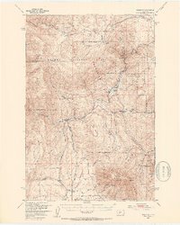
1949 · Manhattan
USGS Topo · 1:62,500
1949 · Maudlow
USGS Topo · 1:62,500