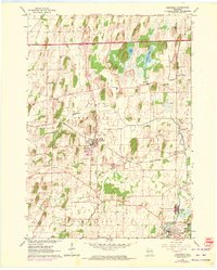
1962 Map of Deerfield
USGS Topo · Published 1972About this map
Deerfield sits at the center of this landscape, where the Chicago and North Western railroad cuts a diagonal line through the rolling marshlands of eastern Dane County. The terrain is defined by glacial remnants, with Koshkonong Creek and Mud Creek winding between numerous drumlins and low-lying basins like Goose Lake and Mud Lake. The map reveals a densely settled rural network of the early 1960s, punctuated by local landmarks such as the Radio Tower (WISC) and several country schools including Liberty Sch and Oak Park Sch.
Find a feature on this map
36 named features on this map. Tap any name to fly to it.
Don’t see what you’re looking for? This feature index may not catch every label — zoom into the map to look around manually.
Map Details
Editions of this 1962 Deerfield Map
2 editions found
Other maps of this area

1890 · Sun Prairie
USGS Topo · 1:62,500

1890 · Stoughton
USGS Topo · 1:62,500

1891 · Waterloo
USGS Topo · 1:62,500

1891 · Koshkonong
USGS Topo · 1:62,500

1894 · Waterloo
USGS Topo · 1:62,500

1894 · Koshkonong
USGS Topo · 1:62,500

1896 · Sun Prairie
USGS Topo · 1:62,500

1905 · Sun Prairie
USGS Topo · 1:62,500

1906 · Koshkonong
USGS Topo · 1:62,500

1907 · Sun Prairie
USGS Topo · 1:62,500