
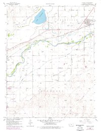
1960 Map of Deerfield
USGS Topo · Published 1961About this map
Lake Mc Kinney dominates the northwestern landscape of this 1960s Kansas survey, serving as a critical reservoir for the extensive irrigation network that sustains the surrounding plains. The town of Deerfield sits at the edge of this hydraulic system, where the Atchison Topeka and Santa Fe railroad corridor runs parallel to the winding Arkansas River. The intricate web of the Amazon Canal, Eastern Ditch, and Great Santa Fe Ditch reveals a landscape defined by water management and agricultural engineering.
Find a feature on this map
18 named features on this map. Tap any name to fly to it.
Don’t see what you’re looking for? This feature index may not catch every label — zoom into the map to look around manually.
Map Details
Editions of this 1960 Deerfield Map
2 editions found
Other maps of this area

1891 · Larned
USGS Topo · 1:125,000

1900 · Lakin
USGS Topo · 1:125,000

1955 · Dodge City
USGS Topo · 1:250,000

1955 · Scott City
USGS Topo · 1:250,000

1958 · Dodge City
USGS Topo · 1:250,000

1958 · Scott City
USGS Topo · 1:250,000

1959 · Dodge City
USGS Topo · 1:250,000
1960 · Deerfield SE
USGS Topo · 1:24,000
1960 · Deerfield SW
USGS Topo · 1:24,000
1960 · Deerfield NE
USGS Topo · 1:24,000