
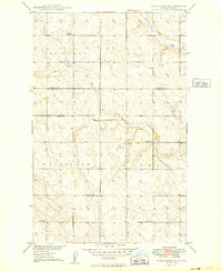
1949 Map of Deering NW
USGS Topo · Published 1949About this map
Bethany Ch and several rural schoolhouses anchor this North Dakota prairie landscape just south of the Renville and Ward County line. Surveyed in the late 1940s, the map reveals a land defined by agricultural division and water management, where Little Deep Creek and its southern tributary, Egg Creek, wind through the terrain. The presence of numbered school sites like School No 1 and School No 4 reflects the decentralized educational system of the era, serving the homesteads that once dotted these townships. Transportation is dominated by the Great Northern railroad, which cuts across the northern landscape near Spring Coulee. The topography is notably marked by large township identifiers, including Ensign, Prescott, Taman, and Margaret, indicating the formal land survey structure that organized the region's development.
Find a feature on this map
13 named features on this map. Tap any name to fly to it.
Don’t see what you’re looking for? This feature index may not catch every label — zoom into the map to look around manually.
Map Details
Editions of this 1949 Deering NW Map
This is the sole edition of this map. No revisions or reprints were ever made.
Other maps of this area

1948 · Lansford
USGS Topo · 1:62,500

1948 · Burlington
USGS Topo · 1:62,500

1949 · Glenburn
USGS Topo · 1:24,000

1949 · Deering SW
USGS Topo · 1:24,000

1949 · Deering SE
USGS Topo · 1:24,000

1949 · Lansford SE
USGS Topo · 1:24,000

1949 · Burlington SE
USGS Topo · 1:24,000

1949 · Eckman SE
USGS Topo · 1:24,000

1949 · Deering
USGS Topo · 1:24,000
1949 · Burlington NE
USGS Topo · 1:24,000