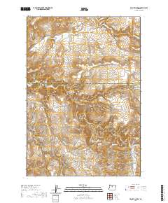
2020 Map of Degner Canyon
USGS Topo · Published 2020About this map
Maupin Cem rests in the southeastern corner of this central Oregon landscape, a site of genealogical significance in a region defined by complex drainage networks. This high-desert terrain is marked by the transition between Wasco County and Jefferson County, where the land is carved by numerous deep incisions including Degner Canyon, Tub Springs Canyon, and Kirkbride Canyon. The presence of Kimsey Springs and Tub Springs suggests the critical importance of reliable water sources in this arid environment, supporting the early ranching and homesteading efforts implied by the local road network. The topography rises toward landmarks like Paulina Butte and Sheep Rock, overlooking basins and hollows such as Paulina Basin and Long Hollow. These features, alongside Timber Culture Gulch, provide a clear picture of the land-use patterns and natural landmarks utilized by generations of inhabitants.
Find a feature on this map
37 named features on this map. Tap any name to fly to it.
Don’t see what you’re looking for? This feature index may not catch every label — zoom into the map to look around manually.
Map Details
Editions of this 2020 Degner Canyon Map
This is the sole edition of this map. No revisions or reprints were ever made.
Other maps of this area

1955 · Bend
USGS Topo · 1:250,000

1957 · Bend
USGS Topo · 1:250,000

1958 · Bend
USGS Topo · 1:250,000

1966 · Antelope
USGS Topo · 1:62,500

1966 · Willowdale
USGS Topo · 1:62,500

1968 · Axehandle Butte
USGS Topo · 1:24,000

1968 · Ashwood
USGS Topo · 1:24,000
1969 · Teller Butte
USGS Topo · 1:24,000

1981 · Stephenson Mountain
USGS Topo · 1:100,000
1987 · Donnybrook
USGS Topo · 1:24,000