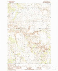
1987 Map of Degner Canyon
USGS Topo · Published 1988About this map
The county line between Wasco Co and Jefferson Co bisects this landscape of drainages and high plateaus, where the terrain transitions from The Flatirons in the west toward the deep incisions of Degner Canyon and Blind Canyon. Water is the primary architect here, with Antelope Creek, Trout Creek, and Pony Creek cutting through the volcanic topography. Local industry and land management are evident in the numerous Storage Bins, scattered Quarry sites, and the naming of Timber Culture Gulch, which likely references early federal reforestation efforts. Genealogists will note the Maupin Cem located near Little Trout Creek, a quiet marker of early settlement in this high desert environment. The presence of features like Paulina Butte and Paulina Basin suggests a complex geomorphology, while several Gravel Pit and Borrow Pit locations indicate ongoing resource extraction as late as the 1980s.
Find a feature on this map
30 named features on this map. Tap any name to fly to it.
Don’t see what you’re looking for? This feature index may not catch every label — zoom into the map to look around manually.
Map Details
Editions of this 1987 Degner Canyon Map
This is the sole edition of this map. No revisions or reprints were ever made.
Other maps of this area

1955 · Bend
USGS Topo · 1:250,000

1957 · Bend
USGS Topo · 1:250,000

1958 · Bend
USGS Topo · 1:250,000

1966 · Antelope
USGS Topo · 1:62,500

1966 · Willowdale
USGS Topo · 1:62,500

1968 · Axehandle Butte
USGS Topo · 1:24,000

1968 · Ashwood
USGS Topo · 1:24,000
1969 · Teller Butte
USGS Topo · 1:24,000

1981 · Stephenson Mountain
USGS Topo · 1:100,000
1987 · Donnybrook
USGS Topo · 1:24,000