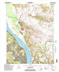
1996 Map of Dekoven
USGS Topo · Published 1998About this map
Ohio River frontage and the rugged hills of the Shawnee National Forest define this landscape along the Kentucky-Illinois border in the late 1990s. The terrain transitions from the low-lying Sturgeon Island and river bottoms to a series of prominent rises including Dodge Hills, Chapel Hills, and Indian Hill. Settlement is concentrated in small riverfront and upland communities such as Caseyville, Dekoven, and Henshaw, while a complex industrial infrastructure is evidenced by a prominent Conveyor line and various mines dotting the hillsides. Numerous rural landmarks provide critical points of reference for local history, ranging from Saint Ambrose Ch in the north to the isolated Bells Mines Ch near the Tradewater River in the south. The convergence of multiple county lines, including Union and Crittenden and Union and Hardin, illustrates the complex jurisdictional boundaries shaped by the rivers.
Find a feature on this map
42 named features on this map. Tap any name to fly to it.
Don’t see what you’re looking for? This feature index may not catch every label — zoom into the map to look around manually.
Map Details
Editions of this 1996 Dekoven Map
This is the sole edition of this map. No revisions or reprints were ever made.
Other maps of this area

1907 · Morganfield
USGS Topo · 1:62,500

1909 · Providence
USGS Topo · 1:62,500

1916 · Shawneetown
USGS Topo · 1:62,500

1916 · Fords Ferry
USGS Topo · 1:62,500

1921 · Fords Ferry
USGS Topo · 1:48,000

1925 · Cave In Rock
USGS Topo · 1:62,500

1949 · Paducah
USGS Topo · 1:250,000

1949 · Morganfield
USGS Topo · 1:24,000

1950 · Paducah
USGS Topo · 1:250,000

1951 · Sturgis
USGS Topo · 1:24,000