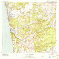
1953 Map of Del Mar
USGS Topo · Published 1954About this map
The coastal communities of Solana Beach and Del Mar define this early 1950s landscape, where the Southern California shoreline meets a complex system of canyons and mesas. The Santa Fe railroad tracks hug the coast, passing the famous Del Mar Race Track and the nearby Del Mar Airport. Inland, the terrain is characterized by deep incisions like Gonzales Canyon and Carmel Valley, which separate the flat expanses of Del Mar Mesa and Kearny Mesa.
Find a feature on this map
36 named features on this map. Tap any name to fly to it.
Don’t see what you’re looking for? This feature index may not catch every label — zoom into the map to look around manually.
Map Details
Editions of this 1953 Del Mar Map
3 editions found
Other maps of this area

1893 · Oceanside
USGS Topo · 1:62,500

1893 · Escondido
USGS Topo · 1:62,500

1898 · Oceanside
USGS Topo · 1:62,500

1901 · Escondido
USGS Topo · 1:62,500

1901 · Oceanside
USGS Topo · 1:62,500

1901 · San Luis Rey
USGS Topo · 1:125,000

1903 · La Jolla
USGS Topo · 1:62,500

1904 · Southern California Sheet No. 2
USGS Topo · 1:250,000

1930 · La Jolla
USGS Topo · 1:62,500

1942 · Poway Valley
USGS Topo · 1:31,680