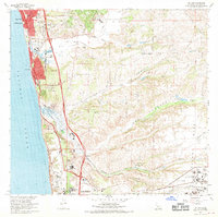
1967 Map of Del Mar
USGS Topo · Published 1970About this map
Solana Beach and Del Mar anchor this coastal landscape during a period of rapid institutional and residential expansion. The map documents the northern edge of the San Diego metropolitan area as it climbs the coastal bluffs, showing established landmarks like the Del Mar Race Track and the Torrey Pines State Reserve. Modernist architectural and scientific footprints are evident with the inclusion of the Salk Institute and the sprawling campus of the Univ of Calif San Diego near the southern boundary.
Find a feature on this map
53 named features on this map. Tap any name to fly to it.
Don’t see what you’re looking for? This feature index may not catch every label — zoom into the map to look around manually.
Map Details
Editions of this 1967 Del Mar Map
3 editions found
Other maps of this area

1893 · Oceanside
USGS Topo · 1:62,500

1893 · Escondido
USGS Topo · 1:62,500

1898 · Oceanside
USGS Topo · 1:62,500

1901 · Escondido
USGS Topo · 1:62,500

1901 · Oceanside
USGS Topo · 1:62,500

1901 · San Luis Rey
USGS Topo · 1:125,000

1903 · La Jolla
USGS Topo · 1:62,500

1904 · Southern California Sheet No. 2
USGS Topo · 1:250,000

1930 · La Jolla
USGS Topo · 1:62,500

1942 · Poway Valley
USGS Topo · 1:31,680