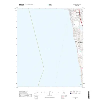
2018 Map of Del Mar OE W
USGS Topo · Published 2018About this map
Solana Beach and Del Mar occupy a narrow strip of coastal development where the southern California cliffs meet the Pacific Ocean. This late-2010s survey illustrates a landscape defined by the tension between dense residential neighborhoods and the natural hydrology of the shore. To the north, the San Dieguito River flows through the San Dieguito Valley before reaching the sea, while further south, the Los Peñasquitos Marsh and Soledad Valley provide a buffer of open terrain near Del Mar Heights. The map traces the grid of historic beach communities, including Eden Gardens and portions of Encinitas, showing how the local road network—from Camino Del Mar to the winding residential ways of Solana Hills Dr—navigates the coastal bluffs. Recreation and conservation are prominent along the shoreline at Torrey Pines City Beach and the secluded Blacks Beach.
Find a feature on this map
64 named features on this map. Tap any name to fly to it.
Don’t see what you’re looking for? This feature index may not catch every label — zoom into the map to look around manually.
Map Details
Editions of this 2018 Del Mar OE W Map
This is the sole edition of this map. No revisions or reprints were ever made.
Other maps of this area

1893 · Oceanside
USGS Topo · 1:62,500

1893 · Escondido
USGS Topo · 1:62,500

1898 · Oceanside
USGS Topo · 1:62,500

1901 · Escondido
USGS Topo · 1:62,500

1901 · Oceanside
USGS Topo · 1:62,500

1901 · San Luis Rey
USGS Topo · 1:125,000

1903 · La Jolla
USGS Topo · 1:62,500

1904 · Southern California Sheet No. 2
USGS Topo · 1:250,000

1930 · La Jolla
USGS Topo · 1:62,500
1942 · Oceanside
USGS Topo · 1:62,500