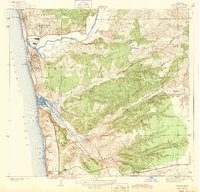
1943 Map of Del Mar
USGS Topo · Published 1943About this map
The coastal communities of Solana Beach and Del Mar anchor this pre-war landscape, where the Atchison Topeka and Santa Fe railroad follows the shoreline before cutting inland through Soledad Valley. Inland, the terrain is defined by deep cuts like Los Penasquitos Canyon and Carmel Valley, revealing a transition from seaside developments to agricultural operations. Notable sites include the Race Track near the mouth of the San Dieguito River and the Mercy Hospital Farm situated on the slopes above the valley floors.
Find a feature on this map
36 named features on this map. Tap any name to fly to it.
Don’t see what you’re looking for? This feature index may not catch every label — zoom into the map to look around manually.
Map Details
Editions of this 1943 Del Mar Map
2 editions found
Other maps of this area

1893 · Oceanside
USGS Topo · 1:62,500

1893 · Escondido
USGS Topo · 1:62,500

1898 · Oceanside
USGS Topo · 1:62,500

1901 · Escondido
USGS Topo · 1:62,500

1901 · Oceanside
USGS Topo · 1:62,500

1901 · San Luis Rey
USGS Topo · 1:125,000

1903 · La Jolla
USGS Topo · 1:62,500

1904 · Southern California Sheet No. 2
USGS Topo · 1:250,000

1930 · La Jolla
USGS Topo · 1:62,500

1942 · Poway Valley
USGS Topo · 1:31,680
Featured Places
- San Diego, CA
- Solana Beach, CA
- Fairbanks Ranch, CA
- Sorrento Valley, San Diego
- Rancho Peñasquitos, San Diego