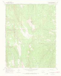
1967 Map of Del Norte Peak
USGS Topo · Published 1969About this map
Del Norte Peak dominates this high-altitude landscape within the Rio Grande National Forest, where steep ridgelines like the Hogback and Mesa define the drainage patterns of the upper Rio Grande basin. The 1967 field survey illustrates a backcountry environment shaped by seasonal resource management rather than permanent settlement. Instead of towns, the map is marked by a network of specialized routes, including a Stock Driveway and several Pack Trails used for moving livestock and equipment through the timber. Significant water sources like Kreps Lake and the confluence of West Fork Shaw Creek and Shaw Creek are primary landmarks. The presence of Ruston Park and Willow Park suggests high-elevation meadows nestled between peaks like Beaver Mountain, while a lone Pipeline cutting across the eastern slopes indicates modern industrial infrastructure crossing the wilderness.
Find a feature on this map
29 named features on this map. Tap any name to fly to it.
Don’t see what you’re looking for? This feature index may not catch every label — zoom into the map to look around manually.
Map Details
Editions of this 1967 Del Norte Peak Map
3 editions found
Other maps of this area

1913 · Summitville
USGS Topo · 1:125,000

1914 · Creede
USGS Topo · 1:125,000

1915 · Summitville
USGS Topo · 1:125,000

1915 · Del Norte
USGS Topo · 1:125,000

1916 · Creede
USGS Topo · 1:125,000

1917 · Del Norte
USGS Topo · 1:125,000

1922 · Conejos
USGS Topo · 1:125,000

1945 · Durango
USGS Topo · 1:250,000

1953 · Durango
USGS Topo · 1:250,000

1954 · Durango
USGS Topo · 1:250,000