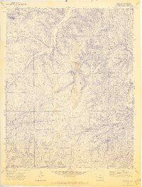
1971 Map of Delagua
USGS Topo · Published 1974About this map
The Apishapa River cuts through this landscape of deep-etched canyons and high plateaus in Las Animas County. By the early 1970s, many of the area's once-active mining and railroad hubs had transitioned to archaeological footprints, as evidenced by Delagua (Site), Vallorso (Site), and Reilly Canyon (Site). These sites point to the region's coal mining heritage, which once sustained bustling communities along the canyon floors.
Find a feature on this map
29 named features on this map. Tap any name to fly to it.
Don’t see what you’re looking for? This feature index may not catch every label — zoom into the map to look around manually.
Map Details
Editions of this 1971 Delagua Map
3 editions found
Other maps of this area

1891 · Spanish Peaks
USGS Topo · 1:125,000

1893 · Spanish Peaks
USGS Topo · 1:125,000

1895 · Spanish Peaks
USGS Topo · 1:125,000

1897 · Spanish Peaks
USGS Topo · 1:125,000

1900 · Spanish Peaks
USGS Topo · 1:125,000

1951 · Trinidad
USGS Topo · 1:24,000

1951 · Madrid
USGS Topo · 1:24,000

1954 · Trinidad
USGS Topo · 1:250,000

1955 · Trinidad
USGS Topo · 1:250,000

1958 · Trinidad
USGS Topo · 1:250,000