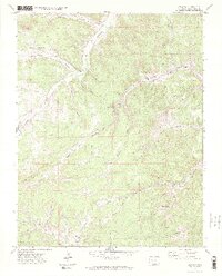
1971 Map of Delagua
USGS Topo · Published 1975About this map
Delagua (Site) and Vallorso (Site) anchor this 1971 study of the Colorado canyonlands, where former mining centers and early settlements are recorded as archaeological footprints. The landscape is defined by deep incisions like Mauricio Canyon and Williams Canyon, which drain into the Apishapa River. Genealogists will find critical details in the presence of family-named landmarks and resting places, such as the Albertson Cem and Trujillo Creek Cem near the small community of Trujillo. The map documents the remnants of the region's extractive economy, notably at the Bear Canyon Mine and numerous unnamed shafts scattered along the steep canyon walls. Industrial and agricultural land use is further indicated by scattered wells and features like Prairie Dog Flat, providing a detailed look at the rural Las Animas County interior before modernization altered these remote sites.
Find a feature on this map
40 named features on this map. Tap any name to fly to it.
Don’t see what you’re looking for? This feature index may not catch every label — zoom into the map to look around manually.
Map Details
Editions of this 1971 Delagua Map
3 editions found
Other maps of this area

1891 · Spanish Peaks
USGS Topo · 1:125,000

1893 · Spanish Peaks
USGS Topo · 1:125,000

1895 · Spanish Peaks
USGS Topo · 1:125,000

1897 · Spanish Peaks
USGS Topo · 1:125,000

1900 · Spanish Peaks
USGS Topo · 1:125,000

1951 · Trinidad
USGS Topo · 1:24,000

1951 · Madrid
USGS Topo · 1:24,000

1954 · Trinidad
USGS Topo · 1:250,000

1955 · Trinidad
USGS Topo · 1:250,000

1958 · Trinidad
USGS Topo · 1:250,000