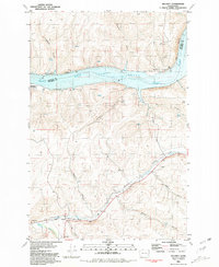
1981 Map of Delaney
USGS Topo · Published 1981About this map
The confluence of the Tucannon River and Pataha Creek anchors this section of southeastern Washington, where the Union Pacific railroad tracks trace the valley floor through Delaney. This landscape is defined by the dramatic descent from the high Camas Prairie plateau into the deep canyons of the Snake River, now widened into Lake Bryan. The presence of a Grain Elevator at the rail siding in Delaney and the Ridpath siding further north highlights the agricultural infrastructure necessary for transporting dryland wheat from the surrounding hills to the river terminals. Numerous named ravines, such as Flagpole Gulch, Browns Gulch, and Hanger Gulch, carve the terrain, illustrating the complex drainage patterns feeding into the main river systems. Small-scale aviation and industrial activity are evident at the Little Goose Landing Strip and various scattered Quarry sites.
Find a feature on this map
30 named features on this map. Tap any name to fly to it.
Don’t see what you’re looking for? This feature index may not catch every label — zoom into the map to look around manually.
Map Details
Editions of this 1981 Delaney Map
This is the sole edition of this map. No revisions or reprints were ever made.
Other maps of this area

1919 · Walla Walla
USGS Topo · 1:125,000

1921 · Walla Walla
USGS Topo · 1:125,000

1937 · Pomeroy
USGS Topo · 1:96,000

1942 · Pomeroy
USGS Topo · 1:125,000

1948 · Starbuck
USGS Topo · 1:62,500

1950 · Starbuck
USGS Topo · 1:62,500

1950 · Hay
USGS Topo · 1:62,500

1952 · Hay
USGS Topo · 1:62,500

1953 · Walla Walla
USGS Topo · 1:250,000

1955 · Pullman
USGS Topo · 1:250,000