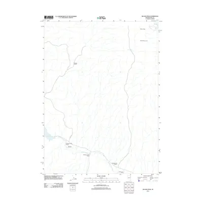
2012 Map of Delano Peak
USGS Topo · Published 2012About this map
Thousand Springs Creek winds through this high-desert landscape in northeastern Elko County, defining the drainage patterns between prominent topographic landmarks. The map area is anchored by Delano Peak and the surrounding Delano Mountains, where the terrain is deeply incised by drainages such as Division Canyon and Twentyone Mile Canyon. Human presence is sparse and concentrated at established ranching sites like Twentyone Mile Ranch and Eighteenmile Ranch, both situated along the lower elevations where water sources are more accessible. Water management in this arid environment is evident through features like the 23 Mile Reservoir and several vital points like Indian Spring and Eighteenmile Spring. These water features and the path of Co HWY-785 reflect the area's ongoing use as rangeland within a complex system of draws and canyons.
Find a feature on this map
13 named features on this map. Tap any name to fly to it.
Don’t see what you’re looking for? This feature index may not catch every label — zoom into the map to look around manually.
Map Details
Editions of this 2012 Delano Peak Map
This is the sole edition of this map. No revisions or reprints were ever made.
Other maps of this area

1955 · Wells
USGS Topo · 1:250,000

1958 · Wells
USGS Topo · 1:250,000

1961 · Wells
USGS Topo · 1:250,000

1961 · Delano Mountains
USGS Topo · 1:62,500

1961 · Dairy Valley
USGS Topo · 1:62,500

1967 · Twelvemile Ranch
USGS Topo · 1:24,000

1967 · Ninemile Mtn NE
USGS Topo · 1:24,000

1967 · Ninemile Mtn
USGS Topo · 1:24,000
1980 · Dry Canyon
USGS Topo · 1:24,000
1981 · Wells
USGS Topo · 1:100,000