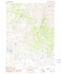
1989 Map of Delano Peak
USGS Topo · Published 1989About this map
Delano Mountains rise sharply in this northeastern Nevada landscape, dominated by the prominent Delano Peak and a network of deep drainage canyons. The area's ranching heritage is anchored by the Twentyone Mile Ranch and Eighteenmile Ranch, positioned near vital water sources like Thousand Springs Creek and the Twentyone Mile Dam. The terrain is marked by numerous prospects on the slopes of the peaks, indicating the area's mineral exploration history during the late twentieth century. Transportation in this high-desert environment is represented by a remote Landing Strip and a series of unimproved trails following natural features like Division Canyon and Eighteenmile Canyon. This survey captures the spatial relationship between isolated livestock operations and the high-elevation springs, such as Indian Spring, that sustain them in the arid Elko County interior.
Find a feature on this map
13 named features on this map. Tap any name to fly to it.
Don’t see what you’re looking for? This feature index may not catch every label — zoom into the map to look around manually.
Map Details
Editions of this 1989 Delano Peak Map
This is the sole edition of this map. No revisions or reprints were ever made.
Other maps of this area

1955 · Wells
USGS Topo · 1:250,000

1958 · Wells
USGS Topo · 1:250,000

1961 · Wells
USGS Topo · 1:250,000

1961 · Delano Mountains
USGS Topo · 1:62,500

1961 · Dairy Valley
USGS Topo · 1:62,500

1967 · Twelvemile Ranch
USGS Topo · 1:24,000

1967 · Ninemile Mtn NE
USGS Topo · 1:24,000

1967 · Ninemile Mtn
USGS Topo · 1:24,000
1980 · Dry Canyon
USGS Topo · 1:24,000
1981 · Wells
USGS Topo · 1:100,000