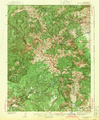
1943 Map of Delano Peak
USGS Topo · Published 1943About this map
The high peaks of the Tushar Mountains dominate this 1943 edition, highlighting the topographic extremes of south-central Utah before modern development. Centered on Delano Peak, the map reveals a landscape defined by its mining and forestry history. The presence of the Sevier Mine near Upper Kimberly and the Deer Trail Mine on the eastern slopes above Marysvale points to a period when mineral extraction was a primary economic driver in the region. This survey, based on field work from the late 1930s, captures the distribution of remote outposts such as Butler Beck Cabin and Telluride Cabin within the Fishlake National Forest. The network of ranger stations, including the Delano Ranger Sta and Big Flat Guard Sta, illustrates the early administrative footprint of the Forest Service in managing these high-altitude meadows and watersheds like Bullion Pasture and Big John Flat.
Find a feature on this map
103 named features on this map. Tap any name to fly to it.
Don’t see what you’re looking for? This feature index may not catch every label — zoom into the map to look around manually.
Map Details
Editions of this 1943 Delano Peak Map
2 editions found
Other maps of this area

1885 · Beaver
USGS Topo · 1:250,000

1932 · Sevier
USGS Topo · 1:62,500

1935 · Sevier
USGS Topo · 1:62,500

1937 · Delano Peak
USGS Topo · 1:48,000

1940 · Monroe
USGS Topo · 1:62,500

1943 · Delano Peak
USGS Topo · 1:62,500

1944 · Monroe
USGS Topo · 1:62,500

1945 · Marysvale
USGS Topo · 1:62,500

1947 · Marysvale
USGS Topo · 1:62,500

1953 · Richfield
USGS Topo · 1:250,000