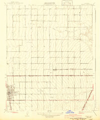
1929 Map of Delano
USGS Topo · Published 1942About this map
Delano serves as the primary hub of activity in this 1920s survey of the southern San Joaquin Valley, appearing as a growing grid defined by its proximity to the Southern Pacific railroad. The map illustrates a landscape transitioning into a sophisticated agricultural engine, where isolated institutions like Columbine Sch and the Sierra Vista Ranch stand amid a vast network of irrigation and surveying lines. The physical boundary between Tulare Co and Kern Co bisects the region, crossing the White River and the ephemeral drainage of Rag Gulch. Further east, the small settlement of Trocha and the distinctive Orange Belt road represent the early transportation corridors that connected these rural orchards and farms to the larger state highway system.
Find a feature on this map
11 named features on this map. Tap any name to fly to it.
Don’t see what you’re looking for? This feature index may not catch every label — zoom into the map to look around manually.
Map Details
Editions of this 1929 Delano Map
2 editions found
Other maps of this area

1927 · McFarland
USGS Topo · 1:31,680

1929 · Delano
USGS Topo · 1:31,680

1929 · Sausalito School
USGS Topo · 1:31,680

1929 · Richgrove
USGS Topo · 1:31,680

1929 · Pixley
USGS Topo · 1:31,680

1929 · Stone
USGS Topo · 1:31,680

1929 · Ducor
USGS Topo · 1:31,680

1930 · McFarland
USGS Topo · 1:31,680

1930 · Pond
USGS Topo · 1:31,680

1931 · Deepwell Ranch
USGS Topo · 1:31,680
Featured Places
- Delano, CA
- Delano Mobile Home Park, Delano
- Cypress Gardens Mobile Home Community, Delano
- Kern County, CA
- Tulare County, CA