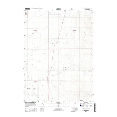
2015 Map of Delaware Creek
USGS Topo · Published 2015About this map
The Humboldt National Forest defines the northwestern boundary of this high-altitude landscape, where the headwaters of two major western drainage systems nearly meet. The terrain is a complex network of seasonal and perennial streams, most notably the Owyhee River flowing north and the N Fork Humboldt River carving through the Valley of the North Fork to the south. This hydrological divide is punctuated by the rising slopes of the Bone Mountains in the southeast. While largely an open range, the area is serviced by the Stevens-Crosby Airport and a grid of rural routes like Tactite Ave and Perlite Rd, hinting at the mineral-based nomenclature of the region. The map captures a transition point between forest service land and private holdings, marked by the confluence of tributaries such as Delaware Cr, McAfee Cr, and Chicken Cr.
Find a feature on this map
26 named features on this map. Tap any name to fly to it.
Don’t see what you’re looking for? This feature index may not catch every label — zoom into the map to look around manually.
Map Details
Editions of this 2015 Delaware Creek Map
This is the sole edition of this map. No revisions or reprints were ever made.
Other maps of this area

1935 · Charleston
USGS Topo · 1:48,000

1942 · Mt. Velma
USGS Topo · 1:62,500

1955 · Wells
USGS Topo · 1:250,000

1956 · Wild Horse
USGS Topo · 1:62,500

1958 · Wells
USGS Topo · 1:250,000

1961 · Wells
USGS Topo · 1:250,000

1971 · Double Mtn
USGS Topo · 1:24,000

1971 · North Fork
USGS Topo · 1:24,000

1971 · California Mtn.
USGS Topo · 1:24,000
1981 · Jarbidge Mts
USGS Topo · 1:100,000