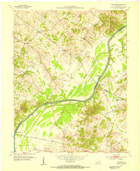
1953 Map of Delaware
USGS Topo · Published 1954About this map
The Green River meanders across this mid-century landscape, serving as a natural boundary between Henderson, Daviess, and McLean counties. In the early 1950s, the region's economy was anchored by small agricultural settlements and active resource extraction, evidenced by the numerous Oil Wells peppered across the hills and valleys. Small riverfront sites like Rangers Landing and Quinn Landing indicate the historical importance of the waterway for local transport and commerce.
Find a feature on this map
31 named features on this map. Tap any name to fly to it.
Don’t see what you’re looking for? This feature index may not catch every label — zoom into the map to look around manually.
Map Details
Editions of this 1953 Delaware Map
Other maps of this area

1905 · Newburg
USGS Topo · 1:62,500

1906 · Sebree
USGS Topo · 1:62,500

1908 · Calhoun
USGS Topo · 1:62,500

1914 · Henderson
USGS Topo · 1:48,000

1916 · Henderson
USGS Topo · 1:62,500

1949 · Sebree
USGS Topo · 1:24,000

1949 · Robards
USGS Topo · 1:24,000

1951 · Sebree
USGS Topo · 1:24,000

1951 · Robards
USGS Topo · 1:24,000

1951 · Spottsville
USGS Topo · 1:24,000