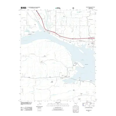
2011 Map of Delaware
USGS Topo · Published 2011About this map
Lake Dardanelle and the Arkansas River corridor dominate this landscape, dividing the map between the southern settlements near Delaware and northern communities like London and Piney. The importance of the waterway is evident through facilities like the Lake Dardanelle State Fish Hatchery and the numerous small creek systems, such as Big Piney Creek and Stinnett Creek, that feed into the main basin. The map reveals a high density of family-named burial grounds including Hon Cemetery, Brock Cemetery, and Stinnett Cemetery, which provide significant value for genealogical research in this part of Pope County.
Find a feature on this map
92 named features on this map. Tap any name to fly to it.
Don’t see what you’re looking for? This feature index may not catch every label — zoom into the map to look around manually.
Map Details
Editions of this 2011 Delaware Map
This is the sole edition of this map. No revisions or reprints were ever made.
Other maps of this area

1888 · Dardanelle #4
USGS Topo · 1:62,500

1888 · Dardanelle #2
USGS Topo · 1:62,500

1888 · Dardanelle #1
USGS Topo · 1:62,500

1888 · Dardanelle #3
USGS Topo · 1:62,500

1890 · Dardanelle
USGS Topo · 1:125,000

1956 · Russellville
USGS Topo · 1:250,000
1962 · Knoxville
USGS Topo · 1:24,000
1962 · New Blaine
USGS Topo · 1:24,000

1962 · Delaware
USGS Topo · 1:24,000
1962 · Clarksville
USGS Topo · 1:24,000