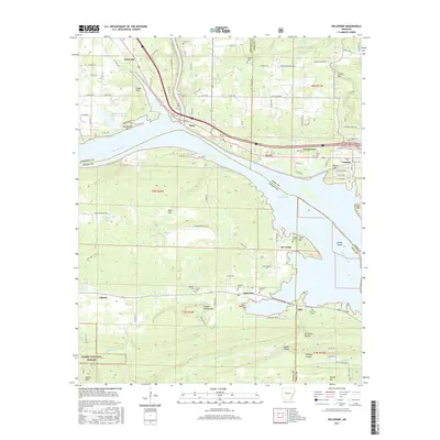
2017 Map of Delaware
USGS Topo · Published 2017About this map
The Arkansas River and the sprawling waters of Lake Dardanelle dominate this landscape at the junction of Johnson, Pope, Logan, and Yell counties. North of the river, the communities of Knoxville, Piney, and London follow the corridor of Highway 64, while the Lake Dardanelle State Fish Hatchery sits near Bluebaugh Hill. The southern bank transitions into the more secluded terrain of the Ozark National Forest, where peaks like River Mtn and Charlie Rollans Mtn rise above the Delaware Cr drainage. Genealogists will find a high density of rural burial sites preserved here, including the Garrison Cem, Chastain Cem, and Pledger Cem. The map illustrates a complex riverfront economy and geography, from the recreational shoreline at Riverside to the industrial and agricultural pockets near Delaware and Sills.
Find a feature on this map
112 named features on this map. Tap any name to fly to it.
Don’t see what you’re looking for? This feature index may not catch every label — zoom into the map to look around manually.
Map Details
Editions of this 2017 Delaware Map
This is the sole edition of this map. No revisions or reprints were ever made.
Other maps of this area

1888 · Dardanelle #4
USGS Topo · 1:62,500

1888 · Dardanelle #2
USGS Topo · 1:62,500

1888 · Dardanelle #1
USGS Topo · 1:62,500

1888 · Dardanelle #3
USGS Topo · 1:62,500

1890 · Dardanelle
USGS Topo · 1:125,000

1956 · Russellville
USGS Topo · 1:250,000
1962 · Knoxville
USGS Topo · 1:24,000
1962 · New Blaine
USGS Topo · 1:24,000

1962 · Delaware
USGS Topo · 1:24,000
1962 · Clarksville
USGS Topo · 1:24,000