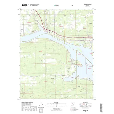
2020 Map of Delaware
USGS Topo · Published 2020About this map
Lake Dardanelle dominates the center of this landscape, marking the convergence of Johnson, Logan, and Pope Counties. The northern shore is anchored by the community of London, where the local terrain rises toward London Mtn and Negro Hill. To the west, the settlement of Knoxville sits above the waters near Clubb Hill. This survey captures the rural character of the Arkansas River Valley, showing a dense network of family and community burial grounds including Shoptaw Cem and Price Cem that indicate long-standing patterns of local settlement.
Find a feature on this map
102 named features on this map. Tap any name to fly to it.
Don’t see what you’re looking for? This feature index may not catch every label — zoom into the map to look around manually.
Map Details
Editions of this 2020 Delaware Map
This is the sole edition of this map. No revisions or reprints were ever made.
Other maps of this area

1888 · Dardanelle #4
USGS Topo · 1:62,500

1888 · Dardanelle #2
USGS Topo · 1:62,500

1888 · Dardanelle #1
USGS Topo · 1:62,500

1888 · Dardanelle #3
USGS Topo · 1:62,500

1890 · Dardanelle
USGS Topo · 1:125,000

1956 · Russellville
USGS Topo · 1:250,000
1962 · Knoxville
USGS Topo · 1:24,000
1962 · New Blaine
USGS Topo · 1:24,000

1962 · Delaware
USGS Topo · 1:24,000
1962 · Clarksville
USGS Topo · 1:24,000