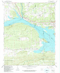
1993 Map of Delaware
USGS Topo · Published 1993About this map
Lake Dardanelle and the Arkansas River dominate this landscape at the intersection of Johnson, Logan, Pope, and Yell counties. The map captures a complex riparian environment where the Ozark National Forest meets the developed shoreline. An abandoned corridor, labeled as an Old Railroad Grade, runs east-west through the southern portion of the map near the community of Delaware, tracing the historical transportation path through the foothills of River Mountain and Charlie Rollans Mountain. Multiple family-named burial grounds like Hon Cem, Chastain Cem, and Brock Cem are noted across the terrain, providing significant value for genealogical research in this river valley region. The presence of the Lake Dardanelle State Fish Hatchery and several public use areas like Delaware Park reflects the mid-century transition of the river into a primary recreation and conservation resource.
Find a feature on this map
60 named features on this map. Tap any name to fly to it.
Don’t see what you’re looking for? This feature index may not catch every label — zoom into the map to look around manually.
Map Details
Editions of this 1993 Delaware Map
This is the sole edition of this map. No revisions or reprints were ever made.
Other maps of this area

1888 · Dardanelle #4
USGS Topo · 1:62,500

1888 · Dardanelle #2
USGS Topo · 1:62,500

1888 · Dardanelle #1
USGS Topo · 1:62,500

1888 · Dardanelle #3
USGS Topo · 1:62,500

1890 · Dardanelle
USGS Topo · 1:125,000

1956 · Russellville
USGS Topo · 1:250,000
1962 · Knoxville
USGS Topo · 1:24,000
1962 · New Blaine
USGS Topo · 1:24,000

1962 · Delaware
USGS Topo · 1:24,000
1962 · Clarksville
USGS Topo · 1:24,000