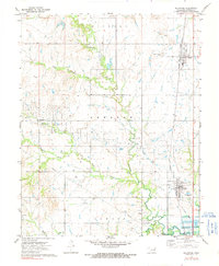
1972 Map of Delaware
USGS Topo · Published 1991About this map
The Missouri Pacific railroad corridor anchors this northeastern Oklahoma landscape, connecting the small prairie towns of Lenapah and Delaware. The area is defined by its early-1970s energy footprint, where the California Oil Field, Lenapah Oil Field, and Delaware Oil Field are densely marked with an extensive network of oil wells, gas wells, and drill holes. These industrial features weave through the drainage basins of California Creek and Wolf Creek, reflecting a land use dominated by petroleum extraction alongside traditional agriculture.
Find a feature on this map
33 named features on this map. Tap any name to fly to it.
Don’t see what you’re looking for? This feature index may not catch every label — zoom into the map to look around manually.
Map Details
Editions of this 1972 Delaware Map
2 editions found
Other maps of this area

1901 · Nowata
USGS Topo · 1:125,000

1914 · Nowata
USGS Topo · 1:125,000

1954 · Tulsa
USGS Topo · 1:250,000

1958 · Tulsa
USGS Topo · 1:250,000

1963 · Tulsa
USGS Topo · 1:250,000

1972 · Blue Mound
USGS Topo · 1:24,000
1972 · Elliott
USGS Topo · 1:24,000

1972 · Nowata West
USGS Topo · 1:24,000
1972 · Delaware
USGS Topo · 1:24,000
1972 · Oglesby
USGS Topo · 1:24,000