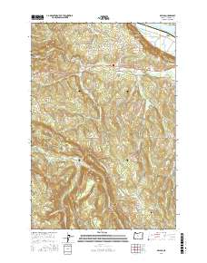
2017 Map of Delena
USGS Topo · Published 2017About this map
Delena and the surrounding Columbia County uplands are defined by a complex network of waterways that eventually feed the Columbia River corridor to the north. In the early 21st century, this landscape remains centered on the small settlements of Alston and Apiary, where the terrain transitions from the low-lying Rineason Slough and Rinearson Point up into the timbered ridges drained by the Clatskanie River and its various forks.
Find a feature on this map
64 named features on this map. Tap any name to fly to it.
Don’t see what you’re looking for? This feature index may not catch every label — zoom into the map to look around manually.
Map Details
Editions of this 2017 Delena Map
This is the sole edition of this map. No revisions or reprints were ever made.
Other maps of this area

1919 · Mayger
USGS Topo · 1:62,500

1921 · Kalama
USGS Topo · 1:62,500

1922 · St. Helens
USGS Topo · 1:62,500

1940 · Vernonia
USGS Topo · 1:62,500

1941 · St Helens
USGS Topo · 1:62,500

1941 · Clatskanie
USGS Topo · 1:62,500

1943 · Vernonia
USGS Topo · 1:62,500

1943 · St Helens
USGS Topo · 1:62,500

1948 · Vancouver
USGS Topo · 1:250,000

1950 · Vancouver
USGS Topo · 1:250,000