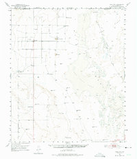
1951 Map of Dell City
USGS Topo · Published 1975About this map
Dell City and the surrounding Trans-Pecos desert are defined by the ancient passage of the Butterfield Trail, which skirts the eastern edge of the Dry Salt Lake Basin. This 1951 landscape is a study in survival within the Salt Flats, where life revolves around water management and livestock. The map documents an extensive network of family-named water sources and landmarks, including Melbeth Tank, Rigsby Windmill, and Hillbilly Windmill. The presence of several large ranching operations like Lynch Ranch and List Ranch, alongside the Salt Flat Airfield and a Radio Range Station, illustrates the era's reliance on both traditional grazing and emerging mid-century aviation infrastructure. Notable geographic markers like Round Mountain and Crow Spring provide critical orientation points in a territory where the Texas-New Mexico border meets the Hudspeth-Otero county lines.
Find a feature on this map
31 named features on this map. Tap any name to fly to it.
Don’t see what you’re looking for? This feature index may not catch every label — zoom into the map to look around manually.
Map Details
Editions of this 1951 Dell City Map
2 editions found
Other maps of this area

1933 · Guadalupe Peak
USGS Topo · 1:48,000

1935 · El Paso Gap
USGS Topo · 1:62,500

1936 · El Paso Gap
USGS Topo · 1:48,000

1940 · El Paso Gap
USGS Topo · 1:62,500

1940 · Guadalupe Peak
USGS Topo · 1:62,500

1951 · Dell City
USGS Topo · 1:62,500

1951 · Red Hills
USGS Topo · 1:62,500

1954 · Carlsbad
USGS Topo · 1:250,000

1954 · Van Horn
USGS Topo · 1:250,000

1955 · Cerro Diablo
USGS Topo · 1:62,500