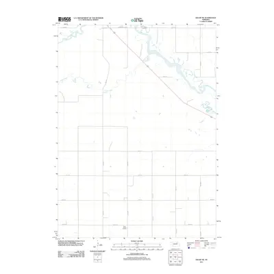
2011 Map of Deloit NE
USGS Topo · Published 2011About this map
The Elkhorn River winds through the northern landscape of this Holt County region, where the South Fork Elkhorn River and Cache Creek contribute to a well-watered agricultural territory. The map reveals a highly structured grid of section roads, including 508th Ave and 849th Rd, which facilitate movement across the rural acreage. For those researching local family history, two significant landmarks appear: Ewing Cemetery in the north and Saint Patricks Cemetery to the south. The presence of Summerland Club Rd suggests a community focal point amidst the fields. This 2011 survey illustrates the modern layout of Nebraska's ranching and farming country, preserving the exact placement of local cemetery grounds and the natural drainage patterns of the Elkhorn basin.
Find a feature on this map
19 named features on this map. Tap any name to fly to it.
Don’t see what you’re looking for? This feature index may not catch every label — zoom into the map to look around manually.
Map Details
Editions of this 2011 Deloit NE Map
This is the sole edition of this map. No revisions or reprints were ever made.
Other maps of this area

1955 · O'Neill
USGS Topo · 1:250,000

1959 · O'Neill
USGS Topo · 1:250,000

1963 · Deloit
USGS Topo · 1:24,000

1963 · Ewing SW
USGS Topo · 1:24,000

1963 · Deloit SW
USGS Topo · 1:24,000

1963 · Neligh SW
USGS Topo · 1:24,000

1963 · Orchard
USGS Topo · 1:24,000

1963 · Ewing
USGS Topo · 1:24,000

1963 · Deloit NE
USGS Topo · 1:24,000
1963 · Clearwater
USGS Topo · 1:24,000