
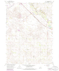
1963 Map of Deloit NE
USGS Topo · Published 1964About this map
The Chicago and North Western railway cuts a sharp diagonal across the northern Nebraska landscape, marking the primary transportation artery for the rural townships of Ewing, Frenchtown, Deloit, and Clearwater. This 1963 survey captures a prairie environment defined by the meandering courses of the Elkhorn River and the South Fork, alongside the slow-moving waters of Cache Creek. The distribution of rural community hubs is evident through a network of one-room schoolhouses and small-town institutions, including Pleasant Hill Sch and Rosedale Sch. Local genealogy and industry are reflected in features such as St Patricks Cem and the small Claypit found in the southern sections. The map also records the exact county line between Holt Co and Antelope Co, illustrating the intersection of civil boundaries with the natural river valleys.
Find a feature on this map
17 named features on this map. Tap any name to fly to it.
Don’t see what you’re looking for? This feature index may not catch every label — zoom into the map to look around manually.
Map Details
Editions of this 1963 Deloit NE Map
2 editions found
Other maps of this area

1955 · O'Neill
USGS Topo · 1:250,000

1959 · O'Neill
USGS Topo · 1:250,000

1963 · Deloit
USGS Topo · 1:24,000

1963 · Ewing SW
USGS Topo · 1:24,000

1963 · Deloit SW
USGS Topo · 1:24,000

1963 · Neligh SW
USGS Topo · 1:24,000

1963 · Orchard
USGS Topo · 1:24,000

1963 · Ewing
USGS Topo · 1:24,000
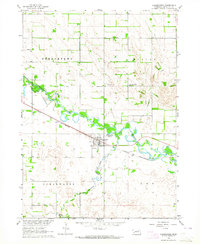
1963 · Clearwater
USGS Topo · 1:24,000

1963 · Deloit NW
USGS Topo · 1:24,000