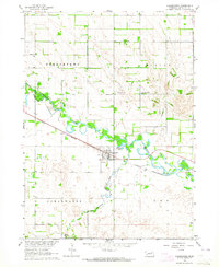
1963 Map of Clearwater
USGS Topo · Published 1964About this map
The town of Clearwater sits at a critical junction of transport and water in Antelope County, Nebraska. This survey shows the village positioned between the Elkhorn River to the north and Clearwater Creek to the south. The Chicago and North Western railroad bisects the landscape, providing the primary industrial artery for the surrounding agricultural townships of Frenchtown, Blaine, and Clearwater. For those researching local family history, the map provides precise locations for several rural burial grounds, including the St Theresa Cem, Clearwater Cem, and the Latter Day Saints Cem. Educational landmarks like School No 8 and the local High School anchor the community's mid-century layout, while the Gaging Station on the creek and the Sewage Disposal Pond reflect the era's civic infrastructure.
Find a feature on this map
18 named features on this map. Tap any name to fly to it.
Don’t see what you’re looking for? This feature index may not catch every label — zoom into the map to look around manually.
Map Details
Editions of this 1963 Clearwater Map
2 editions found
Other maps of this area

1955 · O'Neill
USGS Topo · 1:250,000

1959 · O'Neill
USGS Topo · 1:250,000

1963 · Neligh
USGS Topo · 1:24,000

1963 · Neligh SE
USGS Topo · 1:24,000

1963 · Deloit
USGS Topo · 1:24,000

1963 · Neligh SW
USGS Topo · 1:24,000

1963 · Royal
USGS Topo · 1:24,000

1963 · Orchard
USGS Topo · 1:24,000

1963 · Ewing
USGS Topo · 1:24,000

1963 · Deloit NE
USGS Topo · 1:24,000