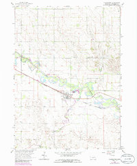
1963 Map of Clearwater
USGS Topo · Published 1986About this map
The Elkhorn River meanders through the central Nebraska landscape, defining the layout of the village of Clearwater. This 1963 survey, photorevised in the mid-1980s, highlights the essential infrastructure of a Great Plains community, from the Chicago and North Western railroad line to the High Sch and several outlying cemeteries. The map illustrates a local reliance on the river and its tributaries, such as Clearwater Creek and Hackberry Creek, for drainage and water management, evidenced by the Sewage Disposal Pond and the Gaging Station downstream.
Find a feature on this map
17 named features on this map. Tap any name to fly to it.
Don’t see what you’re looking for? This feature index may not catch every label — zoom into the map to look around manually.
Map Details
Editions of this 1963 Clearwater Map
2 editions found
Other maps of this area

1955 · O'Neill
USGS Topo · 1:250,000

1959 · O'Neill
USGS Topo · 1:250,000

1963 · Neligh
USGS Topo · 1:24,000

1963 · Neligh SE
USGS Topo · 1:24,000

1963 · Deloit
USGS Topo · 1:24,000

1963 · Neligh SW
USGS Topo · 1:24,000

1963 · Royal
USGS Topo · 1:24,000

1963 · Orchard
USGS Topo · 1:24,000

1963 · Ewing
USGS Topo · 1:24,000

1963 · Deloit NE
USGS Topo · 1:24,000