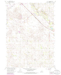
1963 Map of Deloit NE
USGS Topo · Published 1986About this map
The Elkhorn River and its South Fork dominate the northern landscape of this Nebraska quadrangle, where the valley floor gives way to a sprawling network of sand hills and creek beds. The Chicago and North Western railway cuts a sharp diagonal across the prairie, serving as a primary corridor through the Holt Co and Antelope Co borderlands. This region reflects a decentralized rural life, with community life anchored by country schools such as Riverside Sch and Pleasant Hill Sch. Small-scale industrial activity is evident in the presence of a Gravel Pit near the river and a Claypit further south. Local history and genealogy are preserved at Ewing Cem and St Patricks Cem, which stand as landmarks in an area defined by the meandering course of Cache Creek and the vast, undulating terrain of the Missouri River Basin development.
Find a feature on this map
11 named features on this map. Tap any name to fly to it.
Don’t see what you’re looking for? This feature index may not catch every label — zoom into the map to look around manually.
Map Details
Editions of this 1963 Deloit NE Map
2 editions found
Other maps of this area

1955 · O'Neill
USGS Topo · 1:250,000

1959 · O'Neill
USGS Topo · 1:250,000

1963 · Deloit
USGS Topo · 1:24,000

1963 · Ewing SW
USGS Topo · 1:24,000

1963 · Deloit SW
USGS Topo · 1:24,000

1963 · Neligh SW
USGS Topo · 1:24,000

1963 · Orchard
USGS Topo · 1:24,000

1963 · Ewing
USGS Topo · 1:24,000

1963 · Deloit NE
USGS Topo · 1:24,000
1963 · Clearwater
USGS Topo · 1:24,000