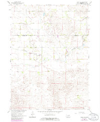
1963 Map of Deloit SW
USGS Topo · Published 1986About this map
The Nebraska Sandhills along the border of Holt and Wheeler counties appear in detail in this 1963 survey. The landscape is defined by the winding course of Clearwater Creek, which meanders through a terrain marked by numerous small depressions and drainage patterns. This map captures the rural social infrastructure of the mid-20th century, notably the School No 146 and the St Anthonys Cem, which serve as vital landmarks for genealogists and local historians tracking the sparse settlement of this prairie region. While the topography is predominantly natural, the presence of isolated wells indicates the essential reliance on groundwater for the ranching operations that characterize this part of Nebraska.
Find a feature on this map
5 named features on this map. Tap any name to fly to it.
Don’t see what you’re looking for? This feature index may not catch every label — zoom into the map to look around manually.
Map Details
Editions of this 1963 Deloit SW Map
2 editions found
Other maps of this area

1954 · Bartlett
USGS Topo · 1:24,000

1955 · Broken Bow
USGS Topo · 1:250,000

1955 · O'Neill
USGS Topo · 1:250,000

1956 · Broken Bow
USGS Topo · 1:250,000

1959 · O'Neill
USGS Topo · 1:250,000

1960 · Spalding 2 NW
USGS Topo · 1:24,000

1960 · Spalding 2 NE
USGS Topo · 1:24,000

1963 · Deloit
USGS Topo · 1:24,000

1963 · Deloit SW
USGS Topo · 1:24,000

1963 · Deloit NE
USGS Topo · 1:24,000