
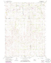
1963 Map of Deloit
USGS Topo · Published 1964About this map
Deloit stands as the primary community in this rural Nebraska landscape, situated near the confluence of Clearwater Creek and its local tributaries. The map, based on 1961 aerial photography and 1963 field checks, reveals a highly organized township system divided among Deloit, Clearwater, Stanton, and Caldwell precincts. This era was characterized by a dense network of one-room schoolhouses distributed throughout the countryside to serve farming families, including School No 46, School No 60, and the Deloit Sch.
Find a feature on this map
20 named features on this map. Tap any name to fly to it.
Don’t see what you’re looking for? This feature index may not catch every label — zoom into the map to look around manually.
Map Details
Editions of this 1963 Deloit Map
2 editions found
Other maps of this area

1955 · Broken Bow
USGS Topo · 1:250,000

1955 · O'Neill
USGS Topo · 1:250,000

1956 · Broken Bow
USGS Topo · 1:250,000

1959 · O'Neill
USGS Topo · 1:250,000

1960 · Spalding 2 NW
USGS Topo · 1:24,000

1960 · Spalding 2 NE
USGS Topo · 1:24,000

1963 · Deloit SW
USGS Topo · 1:24,000

1963 · Neligh SW
USGS Topo · 1:24,000

1963 · Elgin NW
USGS Topo · 1:24,000

1963 · Deloit NE
USGS Topo · 1:24,000