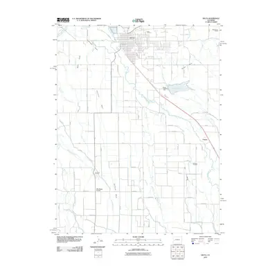
2010 Map of Delta
USGS Topo · Published 2010About this map
The confluence of the Gunnison River and the Uncompahgre River anchors this high-desert landscape, where the city of Delta sits at the northern edge of a sprawling network of irrigation and mesas. The geography is defined by high flatlands like California Mesa, Garnet Mesa, and Ash Mesa, which are systematically subdivided by a grid of agricultural roads and an intricate web of canals, including the Garnet Canal and the Ironstone Canal. This 2010 map shows a meticulously engineered environment where the waters of Sweitzer Lake and various laterals like F L Lateral support the regional orchard and farming economy.
Find a feature on this map
85 named features on this map. Tap any name to fly to it.
Don’t see what you’re looking for? This feature index may not catch every label — zoom into the map to look around manually.
Map Details
Editions of this 2010 Delta Map
This is the sole edition of this map. No revisions or reprints were ever made.
Other maps of this area

1955 · Olathe NW
USGS Topo · 1:24,000

1955 · Olathe
USGS Topo · 1:24,000

1956 · Montrose
USGS Topo · 1:250,000

1956 · Moab
USGS Topo · 1:250,000

1959 · Moab
USGS Topo · 1:250,000

1959 · Montrose
USGS Topo · 1:250,000

1960 · Montrose
USGS Topo · 1:250,000

1960 · Moab
USGS Topo · 1:250,000

1962 · Moab
USGS Topo · 1:250,000
1962 · North Delta
USGS Topo · 1:24,000