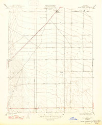
1932 Map of Delta Farms
USGS Topo · Published 1947About this map
Kings County Dev Co Farm No 3 and Delta Farms anchor this landscape in Fresno County, revealing a period of intensive agricultural development in the San Joaquin Valley. The map's grid is dominated by a series of planned roadways named after early twentieth-century automobile manufacturers, including Cadillac Avenue, Ford Avenue, Oakland Avenue, Packard Avenue, and Stutz Avenue. This naming convention reflects the era's optimism regarding mechanized farming and modern transportation.
Find a feature on this map
17 named features on this map. Tap any name to fly to it.
Don’t see what you’re looking for? This feature index may not catch every label — zoom into the map to look around manually.
Map Details
Editions of this 1932 Delta Farms Map
3 editions found
Other maps of this area

1912 · Coalinga
USGS Topo · 1:125,000

1928 · Delta Farms No 3
USGS Topo · 1:31,680

1931 · Wheatville
USGS Topo · 1:31,680

1931 · Towne Oil Station
USGS Topo · 1:31,680

1931 · Mouth of Cantua Creek
USGS Topo · 1:31,680

1932 · Delta Farms
USGS Topo · 1:31,680

1932 · West of Lethent
USGS Topo · 1:31,680

1933 · Huron
USGS Topo · 1:31,680

1933 · Guijarral Hills
USGS Topo · 1:31,680
1936 · Guijarral Hills
USGS Topo · 1:31,680