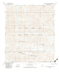
1983 Map of Demarcation Point A-3
USGS Topo · Published 1983About this map
Romanzof Mountains topography dominates this 1980s-era study of the remote North Slope, capturing a landscape defined by sharp elevation changes and high-altitude drainage systems. The map details the protected wilderness areas of the Arctic National Wildlife Refuge and the Arctic Wildlife Refuge Wilderness, where no roads or trails are noted, emphasizing the untouched character of the terrain. Principal watercourses such as the Egaksrak River and the Leffingwell Fork carve through the high country, fed by seasonal flows like Drain Creek. This survey provides a precise record of landmarks like Bathtub Ridge and Plug Mountain, offering essential data for those studying the physical geography of the Brooks Range foothills before modern climate shifts altered these high-latitude environments.
Find a feature on this map
8 named features on this map. Tap any name to fly to it.
Don’t see what you’re looking for? This feature index may not catch every label — zoom into the map to look around manually.
Map Details
Editions of this 1983 Demarcation Point A-3 Map
This is the sole edition of this map. No revisions or reprints were ever made.
Other maps of this area

1951 · Demarcation Point
USGS Topo · 1:250,000

1951 · Table Mountain
USGS Topo · 1:250,000

1955 · Demarcation Point
USGS Topo · 1:250,000

1956 · Table Mountain
USGS Topo · 1:250,000
1956 · Demarcation Point B-4
USGS Topo · 1:63,360
1956 · Demarcation Point B-3
USGS Topo · 1:63,360

1956 · Demarcation Point B-2
USGS Topo · 1:63,360

1964 · Table Mountain
USGS Topo · 1:250,000

1964 · Demarcation Point
USGS Topo · 1:250,000

1983 · Table Mountain D-2
USGS Topo · 1:63,360