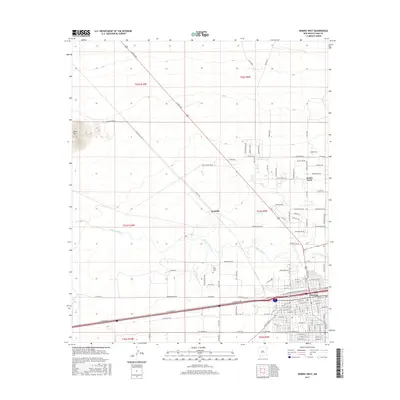
2017 Map of Deming West
USGS Topo · Published 2017About this map
The Mimbres River winds through this High Desert landscape, defining the hydrology of an area where the city of Deming expanded toward the southwest. This 2017 survey shows the transition from the concentrated street grid of the city to the more dispersed agricultural and residential patterns of the surrounding basin. In the rural areas to the north, distinctive features like the volcanic profile of Black Mtn stand in contrast to the developed corridors along N Gold Ave and Winchester Rd. Small settlements and local points of interest, such as Peruhill and Keeler Farm, provide markers of the region's agricultural footprint. For genealogists, the Holy Cross Cem serves as a significant local landmark, while the dense network of rural roads like Racetrack Rd and Florida St Sw illustrates the modern connectivity of Luna County's high plains.
Find a feature on this map
98 named features on this map. Tap any name to fly to it.
Don’t see what you’re looking for? This feature index may not catch every label — zoom into the map to look around manually.
Map Details
Editions of this 2017 Deming West Map
This is the sole edition of this map. No revisions or reprints were ever made.
Other maps of this area

1899 · Deming
USGS Topo · 1:125,000

1915 · Deming
USGS Topo · 1:125,000

1955 · Las Cruces
USGS Topo · 1:250,000

1958 · Las Cruces
USGS Topo · 1:250,000

1964 · Goat Ridge
USGS Topo · 1:24,000
1964 · Spalding
USGS Topo · 1:24,000

1964 · Deming West
USGS Topo · 1:24,000

1964 · Massacre Peak
USGS Topo · 1:24,000
1964 · Williams Ranch
USGS Topo · 1:24,000

1965 · Deming East
USGS Topo · 1:24,000