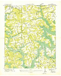
1936 Map of Demory
USGS Topo · Published 1936About this map
Norris Reservoir dominates this 1936 landscape, its jagged shoreline reaching deep into numerous hollows like Whitman Hollow and Sugar Hollow. This Tennessee Valley Authority survey captures the region just as the new reservoir transformed the terrain, creating the sprawling Central Peninsula and establishing new landmarks like Sequoyah Landing. The map is particularly valuable for genealogists, as it documents community centers and burial grounds that were relocated or impacted by the rising waters, such as the Bakers Forge Memorial Cem and New Grantsboro Ch.
Find a feature on this map
41 named features on this map. Tap any name to fly to it.
Don’t see what you’re looking for? This feature index may not catch every label — zoom into the map to look around manually.
Map Details
Editions of this 1936 Demory Map
This is the sole edition of this map. No revisions or reprints were ever made.
Other maps of this area

1893 · Briceville
USGS Topo · 1:125,000

1895 · Briceville
USGS Topo · 1:125,000

1896 · Briceville
USGS Topo · 1:125,000

1897 · Maynardville
USGS Topo · 1:125,000

1900 · Maynardville
USGS Topo · 1:125,000

1935 · Well Spring
USGS Topo · 1:24,000

1936 · Gorryton
USGS Topo · 1:48,000

1936 · Ivydell
USGS Topo · 1:24,000

1936 · Jacksboro
USGS Topo · 1:24,000

1936 · White Hollow
USGS Topo · 1:24,000