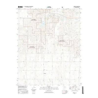
2016 Map of Dempsey
USGS Topo · Published 2016About this map
Black Kettle National Grassland dominates the northern and central sections of this western Oklahoma landscape, punctuated by several managed reservoirs. These impoundments, including the Upper Washita Site 59 Reservoir and Upper Washita Site 60 Reservoir, serve as critical water management points in an area defined by the drainage systems of Croton Cr and Buffalo Cr. The small community of Dempsey sits toward the southern end of the map, providing a central point for the local rural road network. Genealogists and local historians will find the Dempsey Cem just north of the townsite, a key landmark for tracing family roots in Roger Mills County. The terrain is characterized by a high density of small creek branches, such as Middle Buffalo Cr and Brokenleg Cr, which indicate the complex natural irrigation of these grasslands before they meet the Washita River watershed.
Find a feature on this map
33 named features on this map. Tap any name to fly to it.
Don’t see what you’re looking for? This feature index may not catch every label — zoom into the map to look around manually.
Map Details
Editions of this 2016 Dempsey Map
This is the sole edition of this map. No revisions or reprints were ever made.
Other maps of this area

1955 · Clinton
USGS Topo · 1:250,000

1957 · Clinton
USGS Topo · 1:250,000

1960 · Sweetwater
USGS Topo · 1:62,500

1960 · Cheyenne
USGS Topo · 1:62,500

1960 · Sayre
USGS Topo · 1:62,500

1961 · Reydon
USGS Topo · 1:62,500

1984 · Foss Reservoir
USGS Topo · 1:100,000

1985 · Elk City
USGS Topo · 1:100,000
1988 · Grimes
USGS Topo · 1:24,000

1988 · Dempsey
USGS Topo · 1:24,000