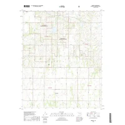
2018 Map of Dempsey
USGS Topo · Published 2018About this map
Black Kettle National Grassland dominates this landscape in Roger Mills County, where the plains are carved by a dense network of seasonal and permanent watercourses. The small community of Dempsey serves as a local anchor point, situated just south of the Dempsey Cem. This 2018 survey reveals a terrain defined by the headwaters of several drainages, including the branching arms of Croton Creek and East Croton Creek to the north, and Middle Buffalo Cr flowing through the southern sections. The map illustrates a strictly organized grid of rural roads, such as E 1030 Rd and N 1770 Rd, which navigate the various land management boundaries of the National Grassland. This area represents a characteristic portion of the Western Oklahoma prairie where public grazing lands and private holdings meet along the breaks of the Red River watershed.
Find a feature on this map
35 named features on this map. Tap any name to fly to it.
Don’t see what you’re looking for? This feature index may not catch every label — zoom into the map to look around manually.
Map Details
Editions of this 2018 Dempsey Map
This is the sole edition of this map. No revisions or reprints were ever made.
Other maps of this area

1955 · Clinton
USGS Topo · 1:250,000

1957 · Clinton
USGS Topo · 1:250,000

1960 · Sweetwater
USGS Topo · 1:62,500

1960 · Cheyenne
USGS Topo · 1:62,500

1960 · Sayre
USGS Topo · 1:62,500

1961 · Reydon
USGS Topo · 1:62,500

1984 · Foss Reservoir
USGS Topo · 1:100,000

1985 · Elk City
USGS Topo · 1:100,000
1988 · Grimes
USGS Topo · 1:24,000

1988 · Dempsey
USGS Topo · 1:24,000