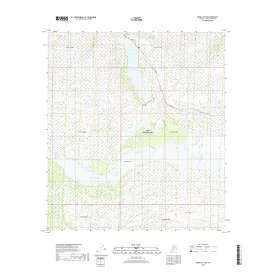
2019 Map of Denali B-2 NW
USGS Topo · Published 2019About this map
Wonder Lake and the McKinley River define this portion of Denali National Park. The survey highlights the essential infrastructure for travelers in this area, including the main Park Road and the Wonder Lake Campground Road. The geography transitions from the deep waters of the lake to the braided channels and gravel deposits of the McKinley Bar. Foot travel is documented along the McKinley Bar Trail, providing a clear record of the human interface with this protected wilderness. Significant watercourses such as Clearwater Creek and Eldorado Cr feed into the regional drainage system, while isolated landmarks like Turtle Hill rise above the surrounding terrain. This data, compiled from various sources including imagery from 2009 and road data from 2016, reflects the preserved state of the landscape in the early twenty-first century.
Find a feature on this map
16 named features on this map. Tap any name to fly to it.
Don’t see what you’re looking for? This feature index may not catch every label — zoom into the map to look around manually.
Map Details
Editions of this 2019 Denali B-2 NW Map
This is the sole edition of this map. No revisions or reprints were ever made.
Other maps of this area

1952 · Mount McKinley
USGS Topo · 1:250,000

1952 · Mount McKinley B-2
USGS Topo · 1:63,360

1952 · Mount McKinley C-3
USGS Topo · 1:63,360

1952 · Mount McKinley C-2
USGS Topo · 1:63,360

1953 · Mount McKinley B-3
USGS Topo · 1:63,360

1954 · Mount McKinley B-3
USGS Topo · 1:63,360

1954 · Mount McKinley B-2
USGS Topo · 1:63,360

1954 · Mount McKinley C-2
USGS Topo · 1:63,360

1958 · Mount McKinley
USGS Topo · 1:250,000

1969 · Mount McKinley
USGS Topo · 1:250,000