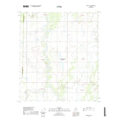
2017 Map of Denali C-5 NE
USGS Topo · Published 2017About this map
Denali National Preserve encompasses the majority of this Alaskan wilderness, where the complex hydrology of the interior takes center stage. The Foraker River meanders through the central terrain, eventually joined by the Herron River in the southwestern reaches. This survey highlights a landscape dominated by shifting watercourses and seasonal drainage patterns, evidenced by features like Hot Slough and the isolated Foraker Pond. The map also captures a significant administrative boundary where the Denali Borough meets the Yukon-Koyukuk Census Area. Free of permanent roads or settlements, the area is defined by its natural water networks and the preservation of the vast, roadless expanse characteristic of the region’s glacial outwash plains.
Find a feature on this map
12 named features on this map. Tap any name to fly to it.
Don’t see what you’re looking for? This feature index may not catch every label — zoom into the map to look around manually.
Map Details
Editions of this 2017 Denali C-5 NE Map
This is the sole edition of this map. No revisions or reprints were ever made.
Other maps of this area

1952 · Mount McKinley
USGS Topo · 1:250,000

1953 · Mount McKinley C-5
USGS Topo · 1:63,360

1953 · Mount McKinley D-5
USGS Topo · 1:63,360

1953 · Mount McKinley C-4
USGS Topo · 1:63,360

1953 · Mount McKinley D-4
USGS Topo · 1:63,360

1954 · Mount McKinley C-4
USGS Topo · 1:63,360

1954 · Mount McKinley D-4
USGS Topo · 1:63,360

1954 · Mount McKinley D-5
USGS Topo · 1:63,360

1954 · Mount McKinley C-5
USGS Topo · 1:63,360

1958 · Mount McKinley
USGS Topo · 1:250,000