
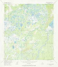
1953 Map of Mount McKinley D-4
USGS Topo · Published 1968About this map
The Muddy River and McKinley River dominate this subarctic landscape, where a complex network of wetlands and namesake lakes defines the interior drainage of the Alaska Range foothills. This 1953 survey, later updated in 1968, records a wilderness nearly devoid of permanent settlements, relying instead on a seasonal Sled Road for overland movement. The hydrology is incredibly dense, featuring a maze of named water bodies like Big Lily Lake, Starr Lake, and the expansive Chilchukabena Lake.
Find a feature on this map
14 named features on this map. Tap any name to fly to it.
Don’t see what you’re looking for? This feature index may not catch every label — zoom into the map to look around manually.
Map Details
Editions of this 1953 Mount McKinley D-4 Map
2 editions found
Other maps of this area

1948 · Kantishna River
USGS Topo · 1:250,000

1951 · Kantishna River
USGS Topo · 1:250,000

1952 · Mount McKinley
USGS Topo · 1:250,000

1952 · Kantishna River A-3
USGS Topo · 1:63,360

1952 · Kantishna River
USGS Topo · 1:250,000

1952 · Mount McKinley C-3
USGS Topo · 1:63,360

1952 · Kantishna River A-5
USGS Topo · 1:63,360

1952 · Mount McKinley D-3
USGS Topo · 1:63,360

1953 · Mount McKinley C-5
USGS Topo · 1:63,360

1953 · Kantishna River A-4
USGS Topo · 1:63,360