1953 Map of Mount McKinley C-5
USGS Topo · Published 1956About this map
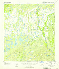
The Foraker River and Herron River dominate this 1950s landscape, their braided channels weaving through a low-lying basin marked by hundreds of small, unnamed kettle lakes and ponds. Based on 1952 aerial photography, the map reveals a remote subarctic environment defined by water and survival. Notable landmarks like Old Cache and Old Cache Lake suggest early trapping or exploration staging areas, while several unnamed Cabin sites are tucked away near the waterways. The drainage patterns are intricate, with Hot Slough and Deep Creek cutting through the northern reaches. This survey captures a moment before modern environmental shifts, showing stable features like Spectacle Lake, Live Trap Lake, and Lake Snohomish within the vast Interior Alaska wilderness.
Find a feature on this map
12 named features on this map. Tap any name to fly to it.
Don’t see what you’re looking for? This feature index may not catch every label — zoom into the map to look around manually.
Map Details
Editions of this 1953 Mount McKinley C-5 Map
2 editions found
Historical Maps of Unorganized Borough Through Time
460 maps found

1949 Fairbanks A-1
Denali Borough, AK

1949 Fairbanks A-2
Denali Borough, AK

1949 Fairbanks B-3
Denali Borough, AK

1949 Fairbanks B-4
Denali Borough, AK

1949 Fairbanks B-5
Denali Borough, AK

1949 Healy B-2
Denali Borough, AK

1949 Healy B-4
Denali Borough, AK

1949 Healy C-3
Denali Borough, AK

1949 Healy D-1
Denali Borough, AK

1950 Fairbanks A-3
Denali Borough, AK

1950 Fairbanks A-4
Denali Borough, AK

1950 Fairbanks A-5
Denali Borough, AK

1950 Fairbanks B-5
Denali Borough, AK

1950 Healy B-3
Denali Borough, AK

1950 Healy B-5
Denali Borough, AK

1950 Healy C-4
Denali Borough, AK

1950 Healy D-3
Denali Borough, AK

1950 Healy D-4
Denali Borough, AK

1951 Fairbanks A-5
Denali Borough, AK

1951 Fairbanks B-5
Denali Borough, AK

1951 Healy B-4
Denali Borough, AK

1951 Healy B-5
Denali Borough, AK

1951 Healy C-1
Denali Borough, AK

1951 Healy C-2
Denali Borough, AK

1951 Healy D-2
Denali Borough, AK

1951 Healy D-5
Denali Borough, AK

1951 Healy D-6
Denali Borough, AK

1951 Mount McKinley D-1
Denali Borough, AK

1952 Fairbanks A-1
Denali Borough, AK

1952 Fairbanks A-2
Denali Borough, AK

1952 Fairbanks A-3
Denali Borough, AK

1952 Fairbanks A-4
Denali Borough, AK

1952 Fairbanks A-6
Denali Borough, AK

1952 Fairbanks B-3
Denali Borough, AK

1952 Fairbanks B-4
Denali Borough, AK

1952 Healy B-2
Denali Borough, AK

1952 Healy B-3
Denali Borough, AK

1952 Healy C-3
Denali Borough, AK

1952 Healy C-4
Denali Borough, AK

1952 Healy C-5
Denali Borough, AK

1952 Healy D-1
Denali Borough, AK

1952 Healy D-2
Denali Borough, AK

1952 Healy D-3
Denali Borough, AK

1952 Healy D-4
Denali Borough, AK

1952 Healy D-5
Denali Borough, AK

1952 Kantishna River A-1
Denali Borough, AK

1952 Kantishna River A-2
Denali Borough, AK

1952 Mount McKinley A-5
Denali Borough, AK

1952 Mount McKinley B-1
Denali Borough, AK

1952 Mount McKinley B-2
Denali Borough, AK

1952 Mount McKinley C-1
Denali Borough, AK

1952 Mount McKinley C-2
Denali Borough, AK

1952 Mount McKinley C-3
Denali Borough, AK

1952 Mount McKinley D-3
Denali Borough, AK

1952 Mount McKinley
Denali Borough, AK

1953 Fairbanks B-6
Denali Borough, AK

1953 Healy B-5
Denali Borough, AK

1953 Healy C-5
Denali Borough, AK

1953 Kantishna River A-1
Denali Borough, AK

1953 Mount McKinley A-4
Denali Borough, AK

1953 Mount McKinley B-3
Denali Borough, AK

1953 Mount McKinley B-4
Denali Borough, AK

1953 Mount McKinley B-5
Denali Borough, AK

1953 Mount McKinley C-4
Denali Borough, AK

1953 Mount McKinley C-5
Denali Borough, AK

1953 Mount McKinley D-4
Denali Borough, AK

1954 Healy C-6
Denali Borough, AK

1954 Healy D-6
Denali Borough, AK

1954 Mount McKinley A-2
Denali Borough, AK

1954 Mount McKinley A-3
Denali Borough, AK

1954 Mount McKinley A-4
Denali Borough, AK

1954 Mount McKinley A-5
Denali Borough, AK

1954 Mount McKinley B-1
Denali Borough, AK

1954 Mount McKinley B-2
Denali Borough, AK

1954 Mount McKinley B-3
Denali Borough, AK

1954 Mount McKinley B-5
Denali Borough, AK

1954 Mount McKinley C-1
Denali Borough, AK

1954 Mount McKinley C-2
Denali Borough, AK

1954 Mount McKinley C-4
Denali Borough, AK

1954 Mount McKinley C-5
Denali Borough, AK

1954 Mount McKinley D-1
Denali Borough, AK

1954 Mount McKinley D-2
Denali Borough, AK

1954 Mount McKinley D-4
Denali Borough, AK

1956 Healy B-5
Denali Borough, AK

1958 Mt McKinley
Denali Borough, AK

1958 Talkeetna D-4
Denali Borough, AK

1958 Talkeetna D-5
Denali Borough, AK

1958 Talkeetna D-6
Denali Borough, AK

1969 Mount McKinley
Denali Borough, AK

1973 Fairbanks A-6
Denali Borough, AK

2013 Fairbanks A-3 NW
Denali Borough, AK

2013 Fairbanks A-4 NE
Denali Borough, AK

2013 Fairbanks A-4 NW
Denali Borough, AK

2013 Fairbanks A-4 SW
Denali Borough, AK

2013 Fairbanks A-5 NE
Denali Borough, AK

2013 Fairbanks A-5 NW
Denali Borough, AK

2013 Fairbanks A-5 SE
Denali Borough, AK

2013 Fairbanks A-5 SW
Denali Borough, AK

2013 Fairbanks A-6 NE
Denali Borough, AK

2013 Fairbanks A-6 NW
Denali Borough, AK

2013 Fairbanks A-6 SE
Denali Borough, AK

2013 Fairbanks A-6 SW
Denali Borough, AK

2013 Fairbanks B-3 SW
Denali Borough, AK

2013 Fairbanks B-4 SE
Denali Borough, AK

2013 Fairbanks B-4 SW
Denali Borough, AK

2013 Fairbanks B-5 SE
Denali Borough, AK

2013 Fairbanks B-5 SW
Denali Borough, AK

2013 Fairbanks B-6 SE
Denali Borough, AK

2013 Fairbanks B-6 SW
Denali Borough, AK

2014 Healy C-6 NW
Denali Borough, AK

2014 Healy C-6 SW
Denali Borough, AK

2014 Healy D-6 NW
Denali Borough, AK

2014 Healy D-6 SW
Denali Borough, AK

2014 Talkeetna D-3 NE
Denali Borough, AK

2014 Talkeetna D-3 NW
Denali Borough, AK

2014 Talkeetna D-4 NE
Denali Borough, AK

2014 Talkeetna D-4 NW
Denali Borough, AK

2014 Talkeetna D-4 SE
Denali Borough, AK

2014 Talkeetna D-4 SW
Denali Borough, AK

2015 Denali A-1 NW
Denali Borough, AK

2015 Denali A-2 NE
Denali Borough, AK

2015 Denali A-2 NW
Denali Borough, AK

2015 Denali A-2 SW
Denali Borough, AK

2015 Denali A-3 NE
Denali Borough, AK

2015 Denali A-3 NW
Denali Borough, AK

2015 Denali A-3 SE
Denali Borough, AK

2015 Denali A-3 SW
Denali Borough, AK

2015 Denali A-4 NE
Denali Borough, AK

2015 Denali A-4 NW
Denali Borough, AK

2015 Denali A-4 SE
Denali Borough, AK

2015 Denali A-4 SW
Denali Borough, AK

2015 Denali B-1 NE
Denali Borough, AK

2015 Denali B-1 NW
Denali Borough, AK

2015 Denali B-1 SW
Denali Borough, AK

2015 Denali B-2 NE
Denali Borough, AK

2015 Denali B-2 NW
Denali Borough, AK

2015 Denali B-2 SE
Denali Borough, AK

2015 Denali B-2 SW
Denali Borough, AK

2015 Denali B-3 NE
Denali Borough, AK

2015 Denali B-3 NW
Denali Borough, AK

2015 Denali B-3 SE
Denali Borough, AK

2015 Denali B-3 SW
Denali Borough, AK

2015 Denali C-1 NE
Denali Borough, AK

2015 Denali C-1 NW
Denali Borough, AK

2015 Denali C-1 SE
Denali Borough, AK

2015 Denali C-1 SW
Denali Borough, AK

2015 Denali C-2 NE
Denali Borough, AK

2015 Denali C-2 NW
Denali Borough, AK

2015 Denali C-2 SE
Denali Borough, AK

2015 Denali C-2 SW
Denali Borough, AK

2015 Denali C-3 NE
Denali Borough, AK

2015 Denali C-3 NW
Denali Borough, AK

2015 Denali C-3 SE
Denali Borough, AK

2015 Denali C-3 SW
Denali Borough, AK

2015 Denali C-4 NE
Denali Borough, AK

2015 Denali C-4 SE
Denali Borough, AK

2015 Denali D-1 NE
Denali Borough, AK

2015 Denali D-1 NW
Denali Borough, AK

2015 Denali D-1 SE
Denali Borough, AK

2015 Denali D-1 SW
Denali Borough, AK

2015 Denali D-2 NE
Denali Borough, AK

2015 Denali D-2 SE
Denali Borough, AK

2015 Denali D-2 SW
Denali Borough, AK

2015 Denali D-3 NW
Denali Borough, AK

2015 Denali D-3 SE
Denali Borough, AK

2015 Denali D-3 SW
Denali Borough, AK

2015 Denali D-4 NE
Denali Borough, AK

2015 Denali D-4 SE
Denali Borough, AK

2016 Denali B-1 SE
Denali Borough, AK

2016 Denali D-2 NW
Denali Borough, AK

2016 Denali D-3 NE
Denali Borough, AK

2016 Fairbanks A-1 NE
Denali Borough, AK

2016 Fairbanks A-1 NW
Denali Borough, AK

2016 Fairbanks A-1 SE
Denali Borough, AK

2016 Fairbanks A-1 SW
Denali Borough, AK

2016 Fairbanks A-2 NE
Denali Borough, AK

2016 Fairbanks A-2 NW
Denali Borough, AK

2016 Fairbanks A-2 SE
Denali Borough, AK

2016 Fairbanks A-2 SW
Denali Borough, AK

2016 Fairbanks A-3 NE
Denali Borough, AK

2016 Fairbanks A-3 SE
Denali Borough, AK

2016 Fairbanks A-3 SW
Denali Borough, AK

2016 Fairbanks B-3 SE
Denali Borough, AK

2016 Healy A-3 NE
Denali Borough, AK

2016 Healy A-3 NW
Denali Borough, AK

2016 Healy A-4 NE
Denali Borough, AK

2016 Healy B-2 NW
Denali Borough, AK

2016 Healy B-2 SW
Denali Borough, AK

2016 Healy B-3 NE
Denali Borough, AK

2016 Healy B-3 NW
Denali Borough, AK

2016 Healy B-3 SE
Denali Borough, AK

2016 Healy B-3 SW
Denali Borough, AK

2016 Healy B-4 NE
Denali Borough, AK

2016 Healy B-4 NW
Denali Borough, AK

2016 Healy B-4 SE
Denali Borough, AK

2016 Healy B-5 NE
Denali Borough, AK

2016 Healy B-5 NW
Denali Borough, AK

2016 Healy B-6 NE
Denali Borough, AK

2016 Healy B-6 NW
Denali Borough, AK

2016 Healy C-1 NE
Denali Borough, AK

2016 Healy C-1 NW
Denali Borough, AK

2016 Healy C-2 NE
Denali Borough, AK

2016 Healy C-2 NW
Denali Borough, AK

2016 Healy C-2 SE
Denali Borough, AK

2016 Healy C-2 SW
Denali Borough, AK

2016 Healy C-3 NE
Denali Borough, AK

2016 Healy C-3 NW
Denali Borough, AK

2016 Healy C-3 SE
Denali Borough, AK

2016 Healy C-3 SW
Denali Borough, AK

2016 Healy C-4 NE
Denali Borough, AK

2016 Healy C-4 NW
Denali Borough, AK

2016 Healy C-4 SE
Denali Borough, AK

2016 Healy C-4 SW
Denali Borough, AK

2016 Healy C-5 NE
Denali Borough, AK

2016 Healy C-5 NW
Denali Borough, AK

2016 Healy C-5 SE
Denali Borough, AK

2016 Healy C-5 SW
Denali Borough, AK

2016 Healy C-6 NE
Denali Borough, AK

2016 Healy C-6 SE
Denali Borough, AK

2016 Healy D-1 NE
Denali Borough, AK

2016 Healy D-1 NW
Denali Borough, AK

2016 Healy D-1 SE
Denali Borough, AK

2016 Healy D-1 SW
Denali Borough, AK

2016 Healy D-2 NE
Denali Borough, AK

2016 Healy D-2 NW
Denali Borough, AK

2016 Healy D-2 SE
Denali Borough, AK

2016 Healy D-2 SW
Denali Borough, AK

2016 Healy D-3 NE
Denali Borough, AK

2016 Healy D-3 NW
Denali Borough, AK

2016 Healy D-3 SE
Denali Borough, AK

2016 Healy D-3 SW
Denali Borough, AK

2016 Healy D-4 NE
Denali Borough, AK

2016 Healy D-4 NW
Denali Borough, AK

2016 Healy D-4 SE
Denali Borough, AK

2016 Healy D-4 SW
Denali Borough, AK

2016 Healy D-5 NE
Denali Borough, AK

2016 Healy D-5 NW
Denali Borough, AK

2016 Healy D-5 SE
Denali Borough, AK

2016 Healy D-5 SW
Denali Borough, AK

2016 Healy D-6 NE
Denali Borough, AK

2016 Healy D-6 SE
Denali Borough, AK

2017 Denali A-5 NE
Denali Borough, AK

2017 Denali A-5 NW
Denali Borough, AK

2017 Denali A-5 SE
Denali Borough, AK

2017 Denali A-5 SW
Denali Borough, AK

2017 Denali A-6 NE
Denali Borough, AK

2017 Denali A-6 NW
Denali Borough, AK

2017 Denali A-6 SE
Denali Borough, AK

2017 Denali A-6 SW
Denali Borough, AK

2017 Denali B-4 NE
Denali Borough, AK

2017 Denali B-4 NW
Denali Borough, AK

2017 Denali B-4 SE
Denali Borough, AK

2017 Denali B-4 SW
Denali Borough, AK

2017 Denali B-5 NE
Denali Borough, AK

2017 Denali B-5 NW
Denali Borough, AK

2017 Denali B-5 SE
Denali Borough, AK

2017 Denali B-5 SW
Denali Borough, AK

2017 Denali B-6 NE
Denali Borough, AK

2017 Denali B-6 NW
Denali Borough, AK

2017 Denali B-6 SE
Denali Borough, AK

2017 Denali B-6 SW
Denali Borough, AK

2017 Denali C-4 NW
Denali Borough, AK

2017 Denali C-4 SW
Denali Borough, AK

2017 Denali C-5 NE
Denali Borough, AK

2017 Denali C-5 NW
Denali Borough, AK

2017 Denali C-5 SE
Denali Borough, AK

2017 Denali C-5 SW
Denali Borough, AK

2017 Denali C-6 NE
Denali Borough, AK

2017 Denali C-6 NW
Denali Borough, AK

2017 Denali C-6 SE
Denali Borough, AK

2017 Denali C-6 SW
Denali Borough, AK

2017 Denali D-4 NW
Denali Borough, AK

2017 Denali D-4 SW
Denali Borough, AK

2017 Denali D-5 NE
Denali Borough, AK

2017 Denali D-5 NW
Denali Borough, AK

2017 Denali D-5 SE
Denali Borough, AK

2017 Denali D-5 SW
Denali Borough, AK

2017 Denali D-6 NE
Denali Borough, AK

2017 Denali D-6 NW
Denali Borough, AK

2017 Denali D-6 SE
Denali Borough, AK

2017 Denali D-6 SW
Denali Borough, AK

2017 Fairbanks A-4 SE
Denali Borough, AK

2017 Kantishna River A-1 NE
Denali Borough, AK

2017 Kantishna River A-1 NW
Denali Borough, AK

2017 Kantishna River A-1 SE
Denali Borough, AK

2017 Kantishna River A-1 SW
Denali Borough, AK

2017 Kantishna River A-2 NE
Denali Borough, AK

2017 Kantishna River A-2 NW
Denali Borough, AK

2017 Kantishna River A-2 SE
Denali Borough, AK

2017 Kantishna River A-2 SW
Denali Borough, AK

2017 Kantishna River A-3 SE
Denali Borough, AK

2017 Kantishna River A-4 SE
Denali Borough, AK

2017 Kantishna River B-1 SE
Denali Borough, AK

2017 Kantishna River B-1 SW
Denali Borough, AK

2017 Kantishna River B-2 SE
Denali Borough, AK

2017 Talkeetna D-5 NE
Denali Borough, AK

2017 Talkeetna D-5 NW
Denali Borough, AK

2017 Talkeetna D-5 SE
Denali Borough, AK

2017 Talkeetna D-5 SW
Denali Borough, AK

2017 Talkeetna D-6 NE
Denali Borough, AK

2017 Talkeetna D-6 NW
Denali Borough, AK

2017 Talkeetna D-6 SE
Denali Borough, AK

2017 Talkeetna D-6 SW
Denali Borough, AK

2019 Denali B-1 NE
Denali Borough, AK

2019 Denali B-1 NW
Denali Borough, AK

2019 Denali B-2 NE
Denali Borough, AK

2019 Denali B-2 NW
Denali Borough, AK

2019 Denali C-1 SE
Denali Borough, AK

2019 Denali C-2 SE
Denali Borough, AK

2019 Denali C-2 SW
Denali Borough, AK

2019 Healy B-4 NW
Denali Borough, AK

2019 Healy B-5 NE
Denali Borough, AK

2019 Healy C-4 NW
Denali Borough, AK

2019 Healy C-5 NE
Denali Borough, AK

2019 Healy C-5 NW
Denali Borough, AK

2019 Healy C-6 NE
Denali Borough, AK

2019 Healy C-6 SE
Denali Borough, AK

2019 Healy C-6 SW
Denali Borough, AK

2019 Healy D-4 SW
Denali Borough, AK

2019 Healy D-5 SW
Denali Borough, AK

2023 Denali A-1 NW
Denali Borough, AK

2023 Denali A-2 NE
Denali Borough, AK

2023 Denali A-2 NW
Denali Borough, AK

2023 Denali A-2 SW
Denali Borough, AK

2023 Denali A-3 NE
Denali Borough, AK

2023 Denali A-3 NW
Denali Borough, AK

2023 Denali A-3 SE
Denali Borough, AK

2023 Denali A-3 SW
Denali Borough, AK

2023 Denali A-4 NE
Denali Borough, AK

2023 Denali A-4 NW
Denali Borough, AK

2023 Denali A-4 SE
Denali Borough, AK

2023 Denali A-4 SW
Denali Borough, AK

2023 Denali A-5 NE
Denali Borough, AK

2023 Denali A-5 NW
Denali Borough, AK

2023 Denali A-5 SE
Denali Borough, AK

2023 Denali A-5 SW
Denali Borough, AK

2023 Denali A-6 NE
Denali Borough, AK

2023 Denali A-6 NW
Denali Borough, AK

2023 Denali A-6 SE
Denali Borough, AK

2023 Denali A-6 SW
Denali Borough, AK

2023 Denali B-1 NE
Denali Borough, AK

2023 Denali B-1 NW
Denali Borough, AK

2023 Denali B-1 SE
Denali Borough, AK

2023 Denali B-1 SW
Denali Borough, AK

2023 Denali B-2 NE
Denali Borough, AK

2023 Denali B-2 NW
Denali Borough, AK

2023 Denali B-2 SE
Denali Borough, AK

2023 Denali B-2 SW
Denali Borough, AK

2023 Denali B-3 NE
Denali Borough, AK

2023 Denali B-3 NW
Denali Borough, AK

2023 Denali B-3 SE
Denali Borough, AK

2023 Denali B-3 SW
Denali Borough, AK

2023 Denali B-4 NE
Denali Borough, AK

2023 Denali B-4 NW
Denali Borough, AK

2023 Denali B-4 SE
Denali Borough, AK

2023 Denali B-4 SW
Denali Borough, AK

2023 Denali B-5 NE
Denali Borough, AK

2023 Denali B-5 NW
Denali Borough, AK

2023 Denali B-5 SE
Denali Borough, AK

2023 Denali B-5 SW
Denali Borough, AK

2023 Denali B-6 NE
Denali Borough, AK

2023 Denali B-6 NW
Denali Borough, AK

2023 Denali B-6 SE
Denali Borough, AK

2023 Denali B-6 SW
Denali Borough, AK

2023 Denali C-1 NE
Denali Borough, AK

2023 Denali C-1 NW
Denali Borough, AK

2023 Denali C-1 SE
Denali Borough, AK

2023 Denali C-1 SW
Denali Borough, AK

2023 Denali C-2 NE
Denali Borough, AK

2023 Denali C-2 NW
Denali Borough, AK

2023 Denali C-2 SE
Denali Borough, AK

2023 Denali C-2 SW
Denali Borough, AK

2023 Denali C-3 NE
Denali Borough, AK

2023 Denali C-3 NW
Denali Borough, AK

2023 Denali C-3 SE
Denali Borough, AK

2023 Denali C-3 SW
Denali Borough, AK

2023 Denali C-4 NE
Denali Borough, AK

2023 Denali C-4 NW
Denali Borough, AK

2023 Denali C-4 SE
Denali Borough, AK

2023 Denali C-4 SW
Denali Borough, AK

2023 Denali C-5 NE
Denali Borough, AK

2023 Denali C-5 NW
Denali Borough, AK

2023 Denali C-5 SE
Denali Borough, AK

2023 Denali C-5 SW
Denali Borough, AK

2023 Denali C-6 NE
Denali Borough, AK

2023 Denali C-6 NW
Denali Borough, AK

2023 Denali C-6 SE
Denali Borough, AK

2023 Denali C-6 SW
Denali Borough, AK

2023 Denali D-1 NE
Denali Borough, AK

2023 Denali D-1 NW
Denali Borough, AK

2023 Denali D-1 SE
Denali Borough, AK

2023 Denali D-1 SW
Denali Borough, AK

2023 Denali D-2 NE
Denali Borough, AK

2023 Denali D-2 NW
Denali Borough, AK

2023 Denali D-2 SE
Denali Borough, AK

2023 Denali D-2 SW
Denali Borough, AK

2023 Denali D-3 NE
Denali Borough, AK

2023 Denali D-3 NW
Denali Borough, AK

2023 Denali D-3 SE
Denali Borough, AK

2023 Denali D-3 SW
Denali Borough, AK

2023 Denali D-4 NE
Denali Borough, AK

2023 Denali D-4 NW
Denali Borough, AK

2023 Denali D-4 SE
Denali Borough, AK

2023 Denali D-4 SW
Denali Borough, AK

2023 Denali D-5 NE
Denali Borough, AK

2023 Denali D-5 NW
Denali Borough, AK

2023 Denali D-5 SE
Denali Borough, AK

2023 Denali D-5 SW
Denali Borough, AK

2023 Denali D-6 NE
Denali Borough, AK

2023 Denali D-6 NW
Denali Borough, AK

2023 Denali D-6 SE
Denali Borough, AK

2023 Denali D-6 SW
Denali Borough, AK

2023 Talkeetna D-3 NE
Denali Borough, AK

2023 Talkeetna D-3 NW
Denali Borough, AK

2023 Talkeetna D-4 NE
Denali Borough, AK

2023 Talkeetna D-4 NW
Denali Borough, AK

2023 Talkeetna D-4 SE
Denali Borough, AK

2023 Talkeetna D-4 SW
Denali Borough, AK

2024 Fairbanks A-6 NW
Denali Borough, AK

2024 Fairbanks A-6 SE
Denali Borough, AK

2024 Fairbanks A-6 SW
Denali Borough, AK

2024 Fairbanks B-6 SW
Denali Borough, AK

2024 Healy A-3 NE
Denali Borough, AK

2024 Healy A-3 NW
Denali Borough, AK

2024 Healy A-4 NE
Denali Borough, AK

2024 Healy B-5 NW
Denali Borough, AK

2024 Healy B-6 NE
Denali Borough, AK

2024 Healy B-6 NW
Denali Borough, AK

2024 Healy C-2 SE
Denali Borough, AK

2024 Healy C-6 NE
Denali Borough, AK

2024 Healy C-6 NW
Denali Borough, AK

2024 Healy C-6 SE
Denali Borough, AK

2024 Healy C-6 SW
Denali Borough, AK

2024 Healy D-6 NE
Denali Borough, AK

2024 Healy D-6 NW
Denali Borough, AK

2024 Healy D-6 SE
Denali Borough, AK

2024 Healy D-6 SW
Denali Borough, AK

2024 Kantishna River A-1 NE
Denali Borough, AK

2024 Kantishna River A-1 NW
Denali Borough, AK

2024 Kantishna River A-1 SE
Denali Borough, AK

2024 Kantishna River A-1 SW
Denali Borough, AK

2024 Kantishna River A-2 NE
Denali Borough, AK

2024 Kantishna River A-2 NW
Denali Borough, AK

2024 Kantishna River A-2 SE
Denali Borough, AK

2024 Kantishna River A-2 SW
Denali Borough, AK

2024 Kantishna River A-3 SE
Denali Borough, AK

2024 Kantishna River A-4 SE
Denali Borough, AK

2024 Kantishna River B-1 SE
Denali Borough, AK

2024 Kantishna River B-1 SW
Denali Borough, AK

2024 Kantishna River B-2 SE
Denali Borough, AK

2024 Talkeetna D-5 NE
Denali Borough, AK

2024 Talkeetna D-5 NW
Denali Borough, AK

2024 Talkeetna D-5 SE
Denali Borough, AK

2024 Talkeetna D-5 SW
Denali Borough, AK

2024 Talkeetna D-6 NE
Denali Borough, AK

2024 Talkeetna D-6 NW
Denali Borough, AK

2024 Talkeetna D-6 SE
Denali Borough, AK

2024 Talkeetna D-6 SW
Denali Borough, AK

2025 Denali A-2 SW
Denali Borough, AK

2025 Denali A-3 SE
Denali Borough, AK