
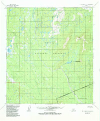
1953 Map of Mount McKinley B-5
USGS Topo · Published 1965About this map
Mt McKinley National Park encompasses the southern reaches of this subarctic landscape, where the glacial drainage systems define the movement across the tundra. The Herron River and Highpower Creek snake through a complex network of wetlands and small kettle lakes, including Little Long Lake and Burnt Lake. The most prominent geological landmark is the Castle Rocks formation, which rises sharply above the surrounding lowlands. A lone Cabin situated near Castle Rocks Lake suggests the presence of seasonal trappers or early park rangers in this remote interior. The topography, based on 1952 aerial photography, captures a wilderness before major modern infrastructure, focused instead on the natural hydrology of the Jack Frost Creek area and the survey marker at VABM 2079 Castle.
Find a feature on this map
10 named features on this map. Tap any name to fly to it.
Don’t see what you’re looking for? This feature index may not catch every label — zoom into the map to look around manually.
Map Details
Editions of this 1953 Mount McKinley B-5 Map
2 editions found
Other maps of this area

1952 · Mount McKinley
USGS Topo · 1:250,000

1952 · Mount McKinley A-5
USGS Topo · 1:63,360

1953 · Mount McKinley C-5
USGS Topo · 1:63,360

1953 · Mount McKinley B-4
USGS Topo · 1:63,360

1953 · Mount McKinley C-4
USGS Topo · 1:63,360

1953 · Mount McKinley A-4
USGS Topo · 1:63,360

1954 · Mount McKinley C-4
USGS Topo · 1:63,360

1954 · Mount McKinley A-4
USGS Topo · 1:63,360

1954 · Mount McKinley B-5
USGS Topo · 1:63,360

1954 · Mount McKinley A-5
USGS Topo · 1:63,360