
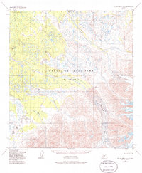
1953 Map of Mount McKinley A-4
USGS Topo · Published 1968About this map
Mt McKinley National Park encompasses a significant portion of this wilderness landscape, showcasing the transition from massive ice fields to the braiding river systems that drain the Alaska Range. The massive Herron Glacier and Foraker Glacier dominate the southeastern topography, feeding into the glacial meltwaters of the Herron River and Foraker River. These drainage patterns reflect the raw environmental forces that have shaped the region's geography for millennia. The map also identifies smaller tributaries like Highpower Creek, White Creek, and Somber Creek, providing a detailed look at the hydrology of the interior before it reaches the broader valley floors. This survey, based on 1952 aerial photography with minor revisions in the late 1960s, documents the state of these receding ice sheets and river courses during a period of active glacial mapping in the territory.
Find a feature on this map
10 named features on this map. Tap any name to fly to it.
Don’t see what you’re looking for? This feature index may not catch every label — zoom into the map to look around manually.
Map Details
Editions of this 1953 Mount McKinley A-4 Map
2 editions found
Other maps of this area

1950 · Talkeetna
USGS Topo · 1:250,000

1951 · Talkeetna
USGS Topo · 1:250,000

1952 · Mount McKinley
USGS Topo · 1:250,000

1952 · Mount McKinley A-5
USGS Topo · 1:63,360

1953 · Mount McKinley B-4
USGS Topo · 1:63,360

1953 · Mount McKinley B-3
USGS Topo · 1:63,360

1953 · Mount McKinley B-5
USGS Topo · 1:63,360

1954 · Mount McKinley A-4
USGS Topo · 1:63,360

1954 · Mount McKinley B-5
USGS Topo · 1:63,360

1954 · Mount McKinley A-5
USGS Topo · 1:63,360