
1953 Map of Mount McKinley B-4
USGS Topo · Published 1956About this map
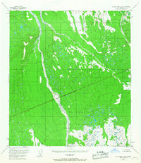
Mt McKinley National Park encompasses a significant portion of this mid-century topographic study, defined by its braided glacial river systems and high-altitude terrain. The Foraker River dominates the western half of the sheet, carving a wide, multi-channeled path through the landscape as it flows northward. To the east, Birch Creek and Slippery Creek drain the upland slopes, illustrating the complex hydrological network of the Alaska Range before modern development. A prominent National Park Boundary (Approximate) bisects the quadrangle diagonally, separating protected wilderness from the surrounding territory. This 1953 data, based on 1952 aerial photography, provides a snapshot of the region's wilderness character and natural drainage patterns, including smaller tributaries like White Creek.
Find a feature on this map
8 named features on this map. Tap any name to fly to it.
Don’t see what you’re looking for? This feature index may not catch every label — zoom into the map to look around manually.
Map Details
Editions of this 1953 Mount McKinley B-4 Map
2 editions found
Other maps of this area

1952 · Mount McKinley
USGS Topo · 1:250,000

1952 · Mount McKinley C-3
USGS Topo · 1:63,360

1952 · Mount McKinley A-5
USGS Topo · 1:63,360

1953 · Mount McKinley C-5
USGS Topo · 1:63,360

1953 · Mount McKinley B-3
USGS Topo · 1:63,360

1953 · Mount McKinley B-5
USGS Topo · 1:63,360

1953 · Mount McKinley C-4
USGS Topo · 1:63,360

1953 · Mount McKinley A-4
USGS Topo · 1:63,360

1954 · Mount McKinley C-4
USGS Topo · 1:63,360

1954 · Mount McKinley A-4
USGS Topo · 1:63,360