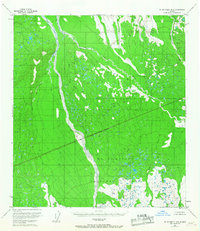
1953 Map of Mount McKinley B-4
USGS Topo · Published 1967About this map
The Mt McKinley National Park boundary bisects this remote subarctic landscape, reflecting the federal management of the Alaska Range mid-century. The Foraker River serves as the dominant hydrological feature, its broad, braided course cutting a wide swath through the western portion of the terrain. This survey, based on 1952 aerial photography and 1953 field annotation, documents a wilderness devoid of roads or trails, where drainage patterns define the geography. Tributaries like Birch Creek, Slippery Creek, and White Creek carve through the high-latitude vegetation, illustrating the transition from glacial runoff to the intricate stream networks of the tundra. The presence of the National Park Boundary (Approximate) highlights the early administrative divisions of this protected wilderness during a period of expanding geological study in the territory.
Find a feature on this map
9 named features on this map. Tap any name to fly to it.
Don’t see what you’re looking for? This feature index may not catch every label — zoom into the map to look around manually.
Map Details
Editions of this 1953 Mount McKinley B-4 Map
2 editions found
Other maps of this area

1952 · Mount McKinley
USGS Topo · 1:250,000

1952 · Mount McKinley C-3
USGS Topo · 1:63,360

1952 · Mount McKinley A-5
USGS Topo · 1:63,360

1953 · Mount McKinley C-5
USGS Topo · 1:63,360

1953 · Mount McKinley B-4
USGS Topo · 1:63,360

1953 · Mount McKinley B-3
USGS Topo · 1:63,360

1953 · Mount McKinley B-5
USGS Topo · 1:63,360

1953 · Mount McKinley C-4
USGS Topo · 1:63,360

1953 · Mount McKinley A-4
USGS Topo · 1:63,360

1954 · Mount McKinley C-4
USGS Topo · 1:63,360